|
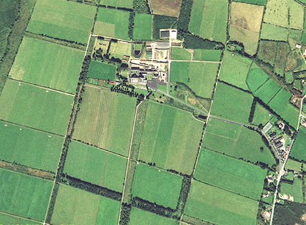
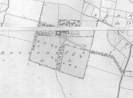
Principal Building |
1: Large Gothic Revival Cistercian limestone abbey church, c.1925, on a cruciform plan arranged east-west along its long axis, with a smaller attached church for public access to the southwest. Structures attached to the north side of the chuch form a courtyard to the north and extend to the east include: an attached five-bay two-storey seminary, established 1834, extended, 1910; and a terraced seven-bay two-storey-over-basement rubble stone boarding house, c.1850, attached four-storey concrete accommodation building, c.2000, to northwest. Detached school building to southeast of complex, c.1850, no longer extant.
|
|
|
2: Interconnected terrace of accommodation buildings and church along north side of main road entrance to east. Church consisting of three-bay double-height Gothic Revival Catholic chapel, c.1850. Accommodation consisting of three seven-bay two-storey over basement rubble stone boarding houses, c.1850, as well as two five-bay two-storey cut-sandstone boarding house, c.1850, and a three-bay two-storey boarding house, c.1850.
|
|
Ornamental Garden |
None
|
|
Ornamental Garden Building |
13: Detached single-storey three-bay timber Summer house, c.1900, to west of complex on west axis complex. Veranda to all sides with slim octagonal iron columns supporting a hipped slate roof. Roof has decorative eaves and finials to centre gables of long sides. White rendered walls with unrendered panels with decorative inlay stones and shells, punctuated by white lattice render framing. Triple lancet sash windows with some decorative glass panels. Main door having decorative panels with lancet motifs flanked by lancet sidelights, decorative crest of arms above door.
|
|
Ornamental Garden Structure |
14: Rock-faced grotto structure north of Summer house, pyramidal profile with central upper niche for Virgin Mary figure and lower cave-like opening at ground level. Brick centre to rear with simple cast-concrete piers, square capitals supporting a concrete arch.
|
|
Plant Collection |
None
|
|
Outbuilding |
9: Farmyard complex north of monastery, c.1860, consisting of ranges of single and two-storey rubble-stone structures on two levels, framing interconnected elongated yards that are also enclosed by rubble-stone walls.
|
|
|
10: Large two-storey rubble-stone outbuildings further to northeast, c.1900, enclosing yard on three sides. Detached recent metal sheds further to north and east of reservoir.
|
|
|
11: Detached single-storey outbuildings, in U-form arrangement, to northwest of new accommodation building, c.1900, having corrugated-iron roof and rubble-stone walls
|
|
|
12: Single-storey outbuildings to southeast of complex, c.1850, recently converted as shop and café for visitors, framing recently paved yard with fountain and amenity planting.
|
|
Productive Garden |
15: Walled garden, c.1850, west of main complex, rubble-stone walls to north, west and south.
|
|
|
16: Walled garden, c.1900, adjoining north side of original walled garden, rubble-stone walls to north, and west. Remains of glass house to north-east wall. Band of large mature beech trees to south side, hornbeam trees along north wall and central walk of mature yew trees running north to south in centre of space. Areas of recent decorative planting to northwest.
|
|
Productive Garden Building |
17: Remains of glasshouse with concrete wall to north boundary of walled garden with ventilation openings, now blocked. Iron heating pipes to south wall.
|
|
|
18: Remains of glass house, c.1900, south of Summer house. Cast-iron columns with decorative acanthus leaf capitals.
|
|
Parkland |
None
|
|
Woodland |
Shelter-belt tree planting, c.1850, following original rectilinear layout marking centre, west and south fields. Belts to north and northeast diminished and several open fields replaced by commercial tree planting. Woodland, c.1850 in rectilinear form, bisected by main approach to southeast of main complex.
|
|
Farmland |
Historic field layout remaining and farm function continuing.
|
|
Water |
19: Several spring sources made the choice of site suitable to establishing the monastery. A small square stone structure, c.1850, located a distance from the monastery, marks the primary well cistern. It has two pointed arch recesses flanking a square-headed door and further recesses to the side elevations, with a carved stone cross finial on the apex of a pyramidal concrete (replacement) roof to the roof. Water collected was passed by pipe to the monastery. A separate well (Whelan’s well) fed the farm, laundry and workshops.
|
|
|
20: Filtration systems, c.1900, some 300m north of the monastery, consisting of filter beds and settling ponds were constructed to guarantee water quality. These works included reservoirs. Construction was overseen by Dungarvan engineer, Michael Beary. This also supplied water hydrants and the monks had their own fire brigade
Filtration systems, c.1900, some 300m north of the monastery, consisting of filter beds and settling ponds were constructed to guarantee water quality. These works included reservoirs. Construction was overseen by Dungarvan engineer, Michael Beary. This also supplied water hydrants and the monks had their own fire brigade
|
|
|
21: Large millpond, c.1880, immediately north of the sawmills and laundry as supply and feed for a water turbine. Elongated north-south orientated wedge plan form with rounded south end and squared north end. Terraced rubble-stone faced embankment to all sides with walkway to top, arched opening to tunnel on south side. Stone steps between levels at different locations, winding stone steps on southwest side of access tunnel connecting to embankment walk. Lower south half of pond floor retaining water, upper section now grassed. Stone lined water channels to north and centre of grassed area, partially bridged for access. Edge of basin formed by squared random rubble-stone walls with stone capping having a decorative edge profile. Decorative stone Gothic-style finials marking ends of half-round basin at south end of central channel, similar finials flanking stone steps to south corners of grasses areas.
|
|
|
22: I million-gallon reservoir, 1913, supply for an electric turbine, located on northern edge of the estate, on ground 50m above the power house. Rectangular plan on east-west orientation.
|
|
Avenue, Drive or Walk |
Canted linear route, c.1830, extending from entrance on Feddaun road to area southeast of main church. Route connecting area north of monastery to Feddaun road, c.1850, no longer extant. Route connecting arrival area at main church to area to south and Feddaun road, c.1830, re-aligned c.1850, no longer complete.
|
|
Gate Lodge or Gateway |
Gate lodge, pre-1843, removed mid-19th century
|
|
|
8: Entrance at main road flanked by metal railing uprights with decorative tops and intermittent decorative scrolled uprights on rendered plinth walls. Ruled-and-lined rendered piers between runs of railings have decorative cornices and cast concrete globe finials on rendered pyramidal cappings. Piers flanking road entrance of ashlar stone with stone cornices and stone orb finials on pyramidal cappings. South section of railings includes cast-iron fountain set in rendered wall framed by decorative fluted pilasters supporting a profiled hood moulding, flanking ruled-and-lined rendered walls, stone trough.
|
|
Boundary or Boundary Wall |
3: Rubble-stone wall with half-round cement capping to road to east.
|
|
|
4: Boundary to church near eastern entrance to east marked by metal railing uprights with decorative finials and intermittent decorative scrolled uprights on rendered plinth walls. Ruled-and-lined rendered piers between runs of railings have decorative cornices and cast concrete globe finials on rendered pyramidal cappings. Double gates to church entrance. Set-back double gates with quadrant walls either end of church boundary.
|
|
|
5: Rubble-stone wall with half-round cement capping to south side of approach road, rendered square piers with cast concrete pyramidal cappings.
|
|
|
6: Terraced arrival area south of main church connected to lower burial ground by flight of concrete steps, ends of flights marked by cast concrete corner piers with square recessed panels and decorative globe finials on pedestals and square cornice cappings. Boundary of terrace marked by low concrete parapet wall with moulded capping profile, punctuated at regular intervals with square concrete piers with recessed Gothic arched panels and capped by moulded finial.
|
|
|
7: Rubble-bank to west boundary of complex with decorative iron gates to east-west route flanked by rendered square piers with pyramidal cappings, pedestrian kissing gate and rendered flanking walls.
|
|
Other |
23: Burial ground, c.1850, south of main church on lower framed in part by hedges and larger clipped shrubs.
|
|
|
24: Circular pool, c.1900, east of Summer house of concrete with square cornice and half round capping. Fountain in centre.
|
|
|
25: Burial ground, c.1850, east of main church laid out in rectilinear arrangement with large decorative stone high cross and small cruciform iron burial markers
|
|
|
26: Garden with religious statues southeast of main church framed by painted concrete parapet wall, similar to that of terrace area directly south of church. Figures standing on pedestals similar in style to parapet piers. Area with religious statues southeast of main church framed by painted concrete parapet wall, similar to that of terrace area directly south of church. Figures standing on pedestals similar in style to parapet piers.
|