Survey Data
Garden No.
GA5389
Townland
Kilaclogher
Present on Ordnance Survey
First Edition: Yes, sheet 106
Second Edition: Yes, area reduced, now named Killaclogher House
Revised Edition: Yes, are reduced, now named Killaclogher House
Garden No.
GA5389
Townland
Kilaclogher
Present on Ordnance Survey
First Edition: Yes, sheet 106
Second Edition: Yes, area reduced, now named Killaclogher House
Revised Edition: Yes, are reduced, now named Killaclogher House
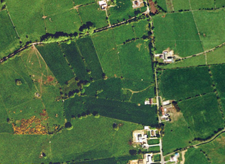
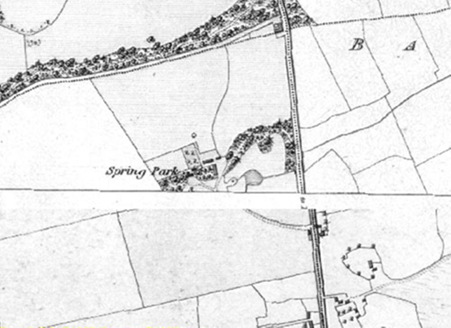
Modest demesne, originally called Spring Park, and changed by 1894 to Killaclogher House; all cleared by 1995. Historic maps indicate that the house which was small faced south-east and was approached from a single entrance and access to the south-east with a spur to the north-east leading to the farmyard and woodland walk, both pre-1840; a small orchard and possible walled garden are also indicated to the north of the house at this time. The demesne appears to have been enlarged, along with the house, by 1894 when the entrance was altered, the walled garden extended, and new areas of woodland to the south and east were planted. A pond is indicated on the First Edition OS Map to the east of the house, this was no longer in place by 1894 but a channel running through its site is indicated on subsequent maps and may still be seen in aerial views.
| Principal Building |
Small south-east facing house, pre-1840, extended by 1894, approached from the south-east; still in-situ by 1932 but gone by 1995 with only traces left in aerial views. |
| Outbuilding |
Farmyard, pre-1840, to east of house, comprising long range running north-south and two smaller buildings to the north, only main range in place by 1894; all gone by 1995. |
| Productive Garden |
Possible small walled garden with orchard, pre-1840, to north of house, possibly extended by 1894 to the north with central dividing wall; now gone, trace of original northern wall to smaller walled garden may still be in place. |
| Parkland |
Parkland, pre-1894, to south and east of house; in use as pasture, road-side housing to the east by 1995. |
| Woodland |
Small area of woodland, pre-1840, to north-east of house with walk; by 1894 tree plantations had been created in areas to the south-west of the house, to the south and east; by 1995 these areas were largely gone, today only a few individual trees remain along former woodland boundaries. |
| Water |
Small pond, pre-1840, to east of house and south of small woodland, no longer indicated on 1894 OS Map, channel runs past site of pond from north-east, this is still visible in aerial views. |
| Avenue, Drive or Walk |
Short curved access, pre-1840, from south-east with spur to yard and woodland area to north-east and second spur to turning area at front of house, intact. |
| Gate Lodge or Gateway |
Entrance to south-east, pre-1840, modified by 1894 to squared shape, reflected on opposite side of road; First Edition OS Map shows a small building to south of entrance which is mentioned as a 'gate house' on Griffith's Valuation, gone by 1894; entrance gone by 1995. |
Griffith's Valuation (1853) recorded James Kenny as the occupier of the land which comprised over 500 acres.
| Overview | |
|---|---|
| Site Footprint Visible | No |
| Boundary Defined | Yes |
| Significant Development | No |
| Architectural Features | |
|---|---|
| Principal Building | No |
| Garden Building | No |
| Buildings of Indeterminate Purpose | No |
| Gateways and Gatehouses | No |
| Avenues, Drives and Walks | |
|---|---|
| Avenue | No |
| Drive or Walk | No |
| Garden Features | |
|---|---|
| Ornamental Garden | No |
| Walled Garden | No |
| Orchard | No |
| Parkland | No |
| Woodland | No |
| Natural Water Feature | No |
| Artifical Water Features | No |
| Allée | No |
| Vista | No |
| Other | No |