Survey Data
Garden No.
GA5353
Landscape Elements
Landscape Park, Plant Collection
Townland
Mounthazel
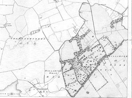
Present on Ordnance Survey
First Edition: Yes, sheet 107
Second Edition: Yes, area reduced
Revised Edition: Yes, area reduced
Garden No.
GA5353
Landscape Elements
Landscape Park, Plant Collection
Townland
Mounthazel
Present on Ordnance Survey
First Edition: Yes, sheet 107
Second Edition: Yes, area reduced
Revised Edition: Yes, area reduced
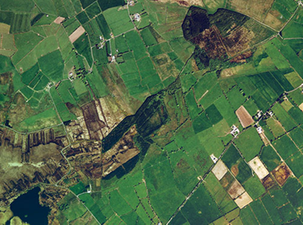
Mount Hazel, pre-1840 and demolished 1945, was an east-facing country house overlooking a fine parkland to the east with considerable woodland, all pre-1840. Today the remains of a walled garden with redbrick lining is located to the north-west of the site of the house on the grounds of the demesne which is now largely cleared of its original woodland and in use for pasture. The gate lodge, pre-1840, which was located opposite the main entrance is still standing but in a derelict condition.
| Principal Building |
1:Said to have been a three-storey country house, built c.1780, east-facing with a garden front and porch or steps to the west, indications of its elevation on a raised ground may be seen on the 25" OS Map; demolished 1945, traces of the southern wall remain. |
| Outbuilding |
4:Farmyard, pre-1840, to north of house comprised two main ranges and a number of individual buildings, only the ruins of one building remains to the south, close to the site of the house. |
| Productive Garden |
5:Walled garden, pre-1840, to north-west of house, with an outer and inner south-west corner, the latter occurring midway along the south wall; included a glasshouse to the south-west by 1893; walls intact but partially ruinous. |
| Parkland |
Parkland, pre-1840, to east of house, now gone. |
| Woodland |
Areas of woodland, pre-1840, to north of house and walled garden, shelter belt to boundary with road to south, pre-1840, all now gone. |
| Water |
Various channels are indicated on the OS maps which show the need to drain the land which lies south of a bog. |
| Avenue, Drive or Walk |
Main access, pre-1840, led from entrance to east and curved gently towards the house through parkland, only visible in aerial views today. |
|
3:Service access, pre-1840, to west of house led to walled garden and track to west side of house, intact if overgrown. |
|
| Gate Lodge or Gateway |
2:Three-bay single-storey gate lodge, pre-1840, to south side of road, opposite site of original entrance, now in use for storage. |
| Other |
Turret, pre-1840, present midway to south wall of walled garden, ruins remain. |
Property originally belonged to the Blake Family; Brownes in residence at the time of the First Ordnance Survey; passed to the McEvoy Family c.1850 through marriage, one of the daughters married the 4th Duc de Stacpoole.
| Overview | |
|---|---|
| Site Footprint Visible | Yes |
| Boundary Defined | Yes |
| Significant Development | No |
| Architectural Features | |
|---|---|
| Principal Building | No |
| Garden Building | No |
| Buildings of Indeterminate Purpose | No |
| Gateways and Gatehouses | Yes |
| Avenues, Drives and Walks | |
|---|---|
| Avenue | No |
| Drive or Walk | No |
| Garden Features | |
|---|---|
| Ornamental Garden | No |
| Walled Garden | Yes |
| Orchard | No |
| Parkland | Yes |
| Woodland | No |
| Natural Water Feature | No |
| Artifical Water Features | No |
| Allée | No |
| Vista | No |
| Other | No |