Garden No.
GA5329
Significance
Significant site - some loss of integrity
Landscape Elements
Ancient Remains, Buildings/Artefacts, Early Formal, Landscape Park, Plant Collection
Townland
Killimor
Present on Ordnance Survey
First Edition: Yes, sheet 106
Second Edition: Yes, area reduced
Revised Edition: Yes, area reduced
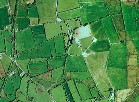
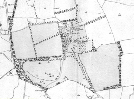
Killimor Casttle is located on a hillside, north of the village of Killimor, close to St. Imor’s Church. An early church devoted to St. Imor was located to the north of an O'Daly castle, built 1574, part of which is now contained within the historic house. As well as the built heritage features of secular and religious importance, the complex of buildings was created around a channel and associated ponds with some woodland arising from a spring to the north, and having a well, 'Tober Imor', to the south of the property. When the demesne was created in the 18th/19th century the picturesque qualities of this ensemble no doubt influenced its layout. Today, the modest landscape park is much altered with modern agriculture, the railway, a conifer plantation to the west and new buildings although the original ensemble of buildings remains intact.
Principal Building |
1: Three-bay two-storey country house, western two-thirds being three storeys of former four-storey medieval tower house of c.1500, remodelled c.1725. |
Outbuilding |
3:Outbuilding, pre-1840, located to north-east of house, formed part of an irregular-shaped yard, still intact. |
Productive Garden |
Walled garden, pre-1840, to north-west of house and St. Imor's, gone by 1933. |
Parkland |
Modest parkland, pre-1840, to south of house with individual trees, subdivided by 1933. |
Woodland |
Small area of mixed woodland, pre-1840 to west of house, largely gone by 1995, fields to west of this area planted with conifers, c.2000; second area of woodland further west to demesne boundary, traversed by Great Southern Railway line in the 1850s, gone by 1995. |
Water |
6:Spring and systems of channels, pre-1840 taking water around the graveyard to the west side of the access road and house, now somewhat re-arranged. |
Avenue, Drive or Walk |
Original access, pre-1840, led from south-west, no longer in use; new road from north includes north portion of this route; new drive created to front of house. |
2:Northern access, pre-1840, led to sanctuary area to north of house, site of access still in use. |
|
Gate Lodge or Gateway |
Original entrance and gate lodge, pre-1840, to south-west, no longer in use; current entrance and access from south-east. |
Other |
5:Ruins of early Christian St. Imor's Church and mid-19th century church to north of house with graveyard; indicated as an area with paths in 1840, close to the spring to the north, gone by 1933. |
4:'Tober Imor', holy well to south of house. |
Overview | |
---|---|
Site Footprint Visible | Yes |
Boundary Defined | Yes |
Significant Development | No |
Architectural Features | |
---|---|
Principal Building | Yes |
Garden Building | No |
Buildings of Indeterminate Purpose | No |
Gateways and Gatehouses | No |
Avenues, Drives and Walks | |
---|---|
Avenue | No |
Drive or Walk | No |
Garden Features | |
---|---|
Ornamental Garden | No |
Walled Garden | No |
Orchard | No |
Parkland | Yes |
Woodland | No |
Natural Water Feature | Yes |
Artifical Water Features | No |
Allée | No |
Vista | No |
Other | No |