Survey Data
Garden No.
DG0048
Landscape Elements
Landscape Park, Plant Collection
Townland
Dunlewy Far
Present on Ordnance Survey
First Edition: Yes, sheet 10
Second Edition: Yes
Revised Edition: Yes
Garden No.
DG0048
Landscape Elements
Landscape Park, Plant Collection
Townland
Dunlewy Far
Present on Ordnance Survey
First Edition: Yes, sheet 10
Second Edition: Yes
Revised Edition: Yes
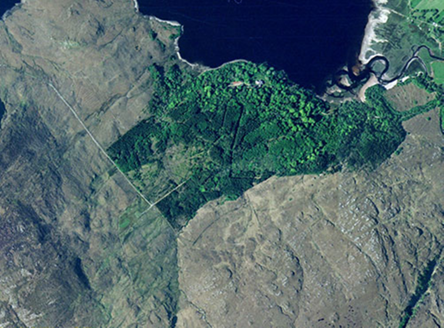
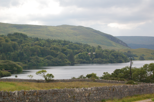
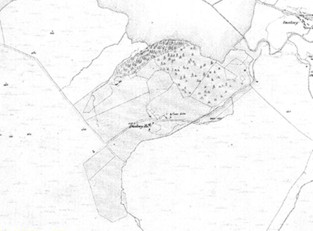
Site originally for pre 1836 house but mainly developed for later Dunlewy House, built to north of earlier building, pre 1857. Set on high ground overlooking Dunlewy Lough. Fine mature trees remain. The area is now heavily wooded.
| Principal Building |
1:Five-bay two-storey house, pre 1857, with battlemented wing and Tudor label mouldings, in good condition. Built for Dumbrene family. The 1836 OS map shows an earlier Dunlewy House to the south of the present house, which appears on the 1857 map for the first time. Earlier house in ruins. |
| Ornamental Garden Building |
3:Stone range of outbuildings, pre 1857, to west of house within a stone walled yard, in use. |
| Ornamental Garden Structure |
According to local information, the previous owner, Cranchet, was responsible for ornamental planting and rockeries within the walled garden. |
| Plant Collection |
Bound by Dunlewy Lough to north |
| Productive Garden |
Stone walled garden to southeast of house, first appears on 1857 map. A few apple trees remain, as do frames for hot beds. Now very overgrown and the present gardener works hard to prevent it from going completely wild. |
| Parkland |
Heavily wooded, especially around the north and east of the demesne, many fine mature trees. |
| Woodland |
Many internal routes remain. |
| Farmland |
Yes. |
| Avenue, Drive or Walk |
Dunlewy Lough to the north. |
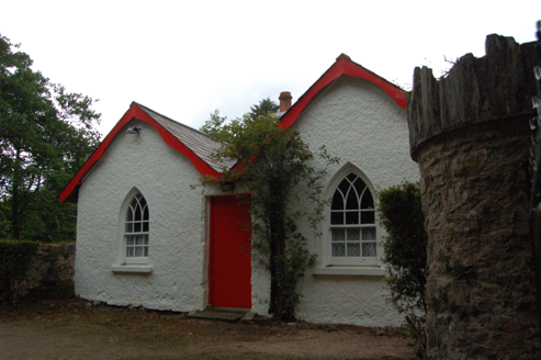
| Gate Lodge or Gateway |
2:Main entrance to east of house. Gate lodge, pre 1857, was originally a single-storey, two roomed lodge, and later extended by an identical addition to form a double pile and the front door moved from the side to the front, harled and whitewashed, in good condition. Circular stone gate piers and cast-iron gate. Secondary entrance south of house. |
| Other |
A boat house is recorded on the 1857 map, to the northwest of the house and is gone by 1906. The 1906 map shows a Boat House and Landing Stage to the east of the house, not seen. |
A stone bothy remains on the western side of the garden, not in use.
Built by the Dombrain family
| Overview | |
|---|---|
| Site Footprint Visible | Yes |
| Boundary Defined | Yes |
| Significant Development | Yes |
| General Comments | Most of site covered by woodland. |
| Architectural Features | |
|---|---|
| Principal Building | No |
| Garden Building | No |
| Buildings of Indeterminate Purpose | No |
| Gateways and Gatehouses | No |
| Avenues, Drives and Walks | |
|---|---|
| Avenue | No |
| Drive or Walk | Yes |
| Garden Features | |
|---|---|
| Ornamental Garden | No |
| Walled Garden | No |
| Orchard | No |
| Parkland | No |
| Woodland | Yes |
| Natural Water Feature | Yes |
| Artifical Water Features | No |
| Allée | No |
| Vista | No |
| Other | No |