Survey Data
Reg No
41401315
Rating
Regional
Categories of Special Interest
Architectural, Technical
Original Use
Mill (water)
In Use As
Barn
Date
1860 - 1880
Coordinates
266976, 330284
Date Recorded
22/04/2012
Date Updated
--/--/--
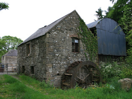
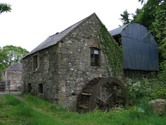
Description
Two-bay two-storey water-powered corn mill, built c.1870, with water-wheel to west gable. Now in use as barn. Pitched natural slate roof, with timber bargeboards having nail-head stud detailing. Random rubble limestone and sandstone walls, with dressed stone quoins. Square-headed window openings, some with camber-arch red brick relieving arches. Replacement metal casement windows throughout. Pitching door to east gable at first floor level, having timber battened double-leaf door. Breast-shot water-wheel with cast-iron axle and rim with some angled wooden paddles. Some coursed rubble stone walling to wheel pit, head race no longer in evidence. hay barn to rear, with corrugated-iron barrel-shaped covering. Miller's house to north-east, with yard of outbuildings. Three-bay two-storey farmhouse to north-east, built c.1870. Hipped slate roof with two red-brick chimneystacks. Terracotta eaves course and roughcast rendered walls. Square-headed window openings with replacement uPVC windows throughout. Three-bay two-storey L-plan farm building to south-east, having hipped slate roof. Roughcast rendered walls, some rubble stone visible. Square-headed window and door openings with recent metal fittings and with two, segmental-headed, stable arches to ground floor, set in corrugated-iron roofed opened sided lean-to porch. Single-storey L-plan outbuilding to north-east of mill, having hipped slate roof, lime washed random rubble stone walls, and square-headed window openings with a mixture of timber three-over-three pane sliding sash windows and timber casement windows. Mill complex, house and outbuildings located to east of river.
Appraisal
The watermill at Tullyleer forms part of a larger milling complex with nearby Tullyleer House and accompanying outbuildings. It is a relatively small mill, and its size, and that of its wheel, suggests that it may have been for corn threshing rather than corn milling. The water-wheel is of technical interest and serves as a reminder of past industrial processes and represents an integral element of the industrial heritage of predominantly agricultural rural Monaghan, which had a high proportion of grain mills. Although buildings are shown in the location of what are now outbuildings on the 1835 OS map, a mill was not present by the time of the 1858 OS survey or the 1860 Griffith Valuation, but is cited on the 1907-08 map as being a corn mill with a mill pond to the south and Tullyleer House to the east.