


Survey Data
Reg No
40909201
Rating
Regional
Categories of Special Interest
Architectural, Social, Technical
Previous Name
Sinclairs Mill
Original Use
Mill (water)
Date
1810 - 1870
Coordinates
183012, 378366
Date Recorded
11/11/2007
Date Updated
--/--/--
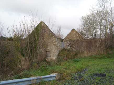
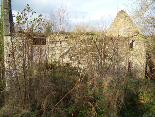
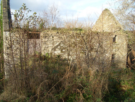
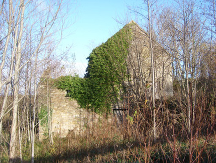
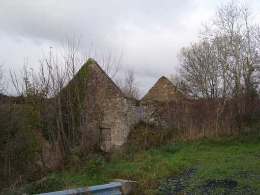
Description
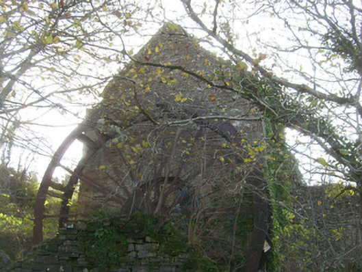
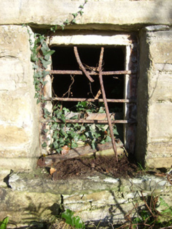
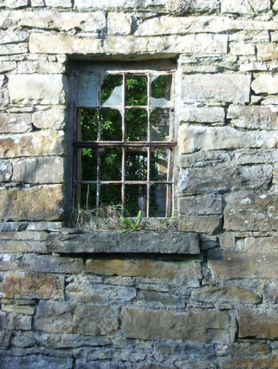
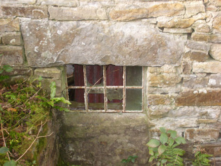
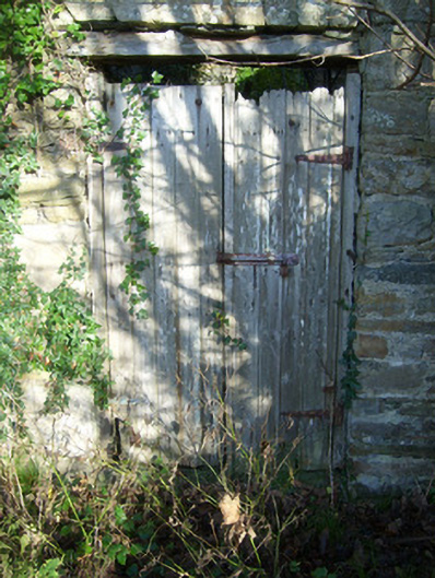
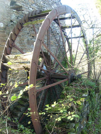
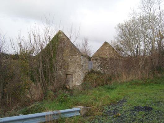
Detached multiple-bay three-storey former corn mill, built or extended c. 1860 and possibly containing the fabric of an earlier mill to site, built c. 1810. Two-storey extension/wing to the west. Now ruinous and out of use. Remains of large composite undershot waterwheel to the north gable end; flight of external stone sets adjacent to waterwheel. Ramp to the east elevation allowing access to doorway at upper floor level. Pitched natural slate roof, now collapsed, and having raised verges to gable ends. Coursed squared rubble stone and rubble stone construction with roughly dressed flush quoins to the corners. Square-headed window openings with stone sills and having remains of multi-pane cast-iron/metal windows. Wrought-iron security bars to a number ground floor window openings. Square-headed door openings with remains of timber battened doors. Composite metal waterwheel to north elevation with surviving timber paddles; internal corn-grinding mechanism now collapsed but surviving. Remains of rubble stone former corn kiln adjacent to the west. Set back from road in overgrown grounds to the west of Mountcharles and to the east of Inver Church of Ireland church. Former mill pond, now dry, to the east; linked to mill by headrace running from the east with remains of sluice. Tailrace to the west formerly discharging into a small stream/unnamed tributary of the Eany Water.
Appraisal
Although now sadly ruinous, this former corn mill complex retains its early form and much of its early industrial character. The unrefined rubble stone construction and the irregular spacing of the openings give these structures a vaguely vernacular appearance. Of particular significance is the survival of a large composite metal waterwheel with timber buckets/paddles to the north elevation, which provides an interesting insight into past industrial processes. The form of this millwheel suggests that it is an undershot wheel. This waterwheel was powered using water stored in a large mill pond to the east (now dry) with the flow of water along the headrace controlled by a sluice or sluices adjacent to the east of the waterwheel (Ordnance Survey twenty-five inch map sheet 1907). Some of the internal machinery and a number of millstones survive to the interior, albeit in increasingly poor condition. Although this former corn mill probably largely dates to the second half of the nineteenth-century, it occupies the site of and possibly incorporates the remains of a small corn mill built during early-nineteenth century (or possibly the late-eighteenth century), which was a boom period for the Irish corn milling industry. This mill was reputedly built by the Revd. Alexander Montgomery, who was both the local landlord owning the Bonneyglen estate (house demolished) to the north and the Drumbeg House/Cloverhill estate (see 40909809) to the south-east, as well as the local rector for 49 years until his death in 1848. O’Donovan records a corn mill here in 1835 (Ordnance Survey Letters) and a small building is depicted here on the Ordnance Survey first edition six-inch map of 1837. This mill later passed into the ownership of William Sinclair of County Tyrone, a relative of the Revd. Montgomery, and the mill was known locally for many years as ‘Sinclairs Mill’ as a result. Griffith’s Valuation of c. 1857 records that this mill was still in the ownership of Sinclair at this time, and that the holding consisted of a corn mill, kiln, miller’s house, offices and land totalling over twenty acres. The mill was rented to a James Killin in 1866. The mill remained in the ownership of the Sinclair family until the lat- nineteenth or early-twentieth century when it was purchased by the Congested District Board. It was later bought by the Glackin family, who ran the mill until its eventual closure in the 1950s. This former industrial building, although now derelict, remains an important physical reminder of past industrial processes and represents an integral element of the industrial, social and economic history of the Inver area. The remains of the former head and tailraces, and the ruins of a former corn kiln to the west add to the setting, and provide further context to the understanding of this site.