


Survey Data
Reg No
40905303
Rating
Regional
Categories of Special Interest
Architectural, Historical
Original Use
Country house
Date
1760 - 1830
Coordinates
215258, 410944
Date Recorded
05/12/2008
Date Updated
--/--/--
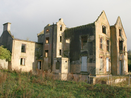
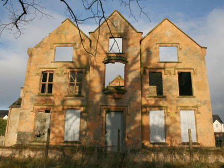
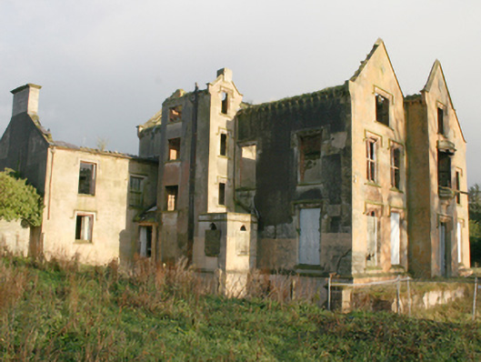
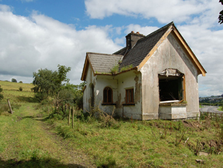
Description
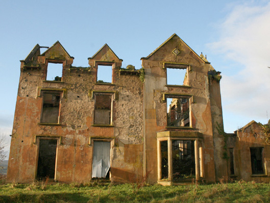
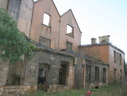
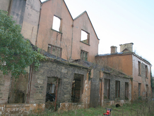
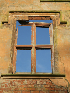
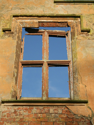
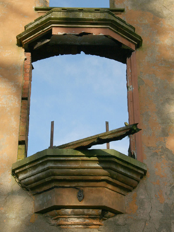
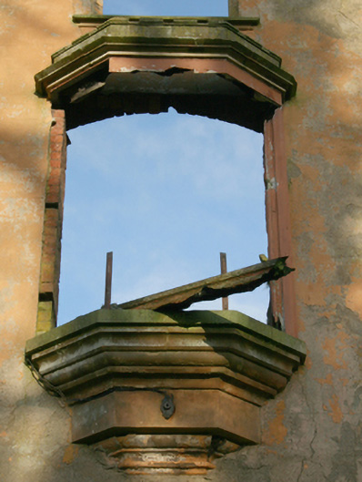
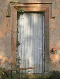
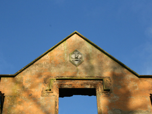
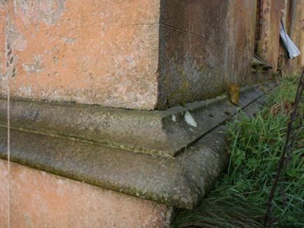
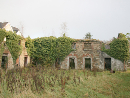
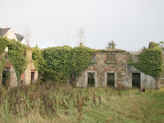
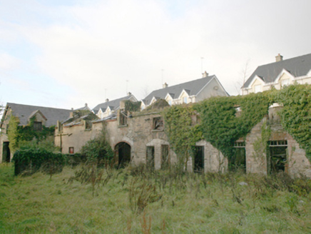
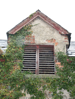
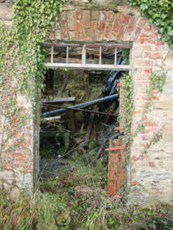
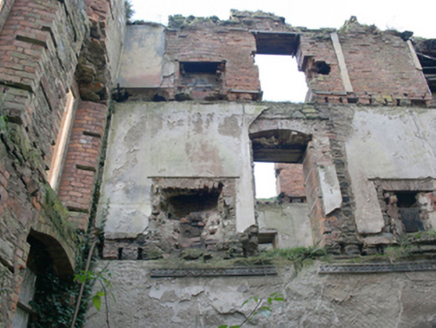
Detached five-bay three-storey over basement former county house, built c. 1770 and altered c. 1830, having three gables to entrance front (east) with central projecting gable-fronted breakfront having oriel window at first floor level, four-storey over basement block to west elevation, three-bay three-storey over basement elevation to east having half-dormer openings to south and three-storey gable-fronted projection to the north with single-storey canted bay window at ground floor level, single-storey multi-bay bay to rear (west), and two-bay two-storey block to north-west corner. Now a ruin following fire in recent years. Collapsed pitched natural slate roofs. Cut stone eaves course with corbelled sandstone brackets, cut stone coping over gable-fronted bays and half-dormer openings having kneeler stones at eaves level, and with remains of brick and rendered chimneystacks. Smooth rendered ruled-and-lined walls over moulded ashlar plinth course at ground floor level; brick construction evident to interior, rubble stone construction evident in places. Carved decorative plaques to gable apexes to front elevation, one inscribed ‘Bon Fido’. Square-headed window openings with remains of timber casement windows with mullion and transoms, chamfered stone sills, ashlar sandstone hoodmouldings, and chamfered reveals. Square-headed window openings to block to the south-west having remains of timber sliding sash windows. Ashlar corbelling to base of oriel window with moulded cornice over. Square-headed doorway to the centre of the east elevation having staged ashlar sandstone surround, hoodmoulding over, and with remains of timber panelled double-doors; doorway now blocked. Set back from road in own grounds with modern housing development encroaching to the north, remnant gardens to front (east) and south, remnant woodland to east, rubble stone boundary wall to north, and remnant driveway to east. Detached two-storey outbuilding (on U-shaped plan) to the north-east, now also ruinous, having now largely collapsed pitched natural slate roofs with cut stone eaves, roughcast rendered chimneystacks, and gable-fronted half-dormer openings to block to the west. Rubble stone walls with remains of lime render over. Square-headed window openings with red brick reveals, cut sandstone sills, remains of timber windows, and with timber louvered fittings to half-dormer openings. Square-headed door openings with red brick surrounds, and remains of timber doors and overlights. Segmental-headed carriage-arches with red brick surrounds (some now infilled). Altered single-storey with dormer attic level gate lodge to the east, built c. 1830, now converted for use as a public house and extended. Detached single-storey former gate lodge to the south-west, now ruinous, having central gable-fronted porch to the front elevation (north-west) and canted bay window to the south-west gable end. Pitched slate roofs with central rendered chimneystack, square-headed window openings to main body of building with remains of timber windows; round-headed window opening to the south-west side of porch having remains of timber windows with timber tracery. Recessed round-headed doorway with remains of timber fittings.
Appraisal
This formerly impressive and complex large-scale country house is now an interesting and quite picturesque ruin in the landscape to the south-west of Letterkenny. Of particular interest is the fine entrance front with three gables, and central breakfront with the remains of an elegant oriel window at first floor level. Its former glory can be discerned in the extensive high-quality cut sandstone detailing, particularly to the verges over the gables and half-dormers, the hoodmouldings over the door, the fine staged doorcase to the main entrance and the plaques to the front gable apexes. This building was originally constructed sometime around the mid-eighteenth century. It was originally a typical five-bay two-storey mid-Georgian structure possibly with a shallow breakfront to the centre of the entrance front. It was later heavily rebuilt, c. 1830, in a Tudor Revival idiom with the gables, half-dormers and a third floor added, the timber sash windows replaced with timber casement windows with mullions, transoms and hoodmouldings, and a corbelled oriel window over the doorway. The designer responsible for these alterations is not known though it has been suggested by Rowan (1979) that the Dublin-based architect John Hargrave (1788-1833), who had carried out works at nearby Rockhill House (see 40906102) to the south-west sometime after 1823. This house was the residence of the Span family during the second half of the eighteenth century. The house is depicted on the Taylor and Skinner road map of the area from 1777-83 when it was the home of Span Esq. However, some sources indicate that the Boyd family came into the ownership of the lands at Ballymacool in 1672 (by claiming descent from a younger branch of the Scottish Earls of Kilmarnock) and built a house here shortly afterwards. John Boyd, born in 1739, and High Sheriff of Donegal in 1772–73, apparently purchased the Ballymacool House and estate from Samuel Span (a Bristol-born merchant) in 1785 for £3,000. The estate was later passed to his eldest son John Boyd, a barrister, in 1799. He was succeeded by his nephew, William Henry Porter, under the condition that he assume the surname Boyd, which he did by Royal License in 1891. The house became occupied by Republican soldiers in 1921. The Boyd family remained at Ballymacool until 1940 when the house was put up for sale. The Weekly Irish Times, dated May 11, 1940, described the Ballymacool Estate as ‘well-kept and extensive gardens embellished by the pine walk near the house, comprising a variety of rare conifers, amongst which are some of the finest specimens in Ireland’. This roofless shell now acts as a picturesque feature in the landscape to the south-west suburbs of Letterkenny with modern housing encroaching to the north. It is an integral element of the built heritage and social history of the Letterkenny area, and acts as an historical reminder of the Boyd and Span families who resided there for over two hundred years. The large but ruinous range of outbuildings to the north provides an historical insight into the resources required to run and maintain a large estate in Ireland during the nineteenth century. The simple ruinous gate lodge to the south-west adds to the setting and context. An additional gate lodge to the east has now been altered and extended.