


Survey Data
Reg No
40901517
Rating
Regional
Categories of Special Interest
Archaeological, Architectural, Social
Original Use
Graveyard/cemetery
In Use As
Graveyard/cemetery
Date
1600 - 1800
Coordinates
202220, 436720
Date Recorded
15/11/2010
Date Updated
--/--/--
Description
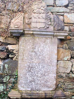
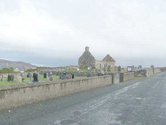
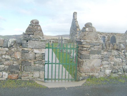
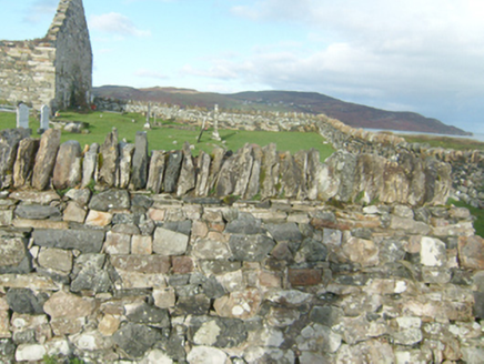
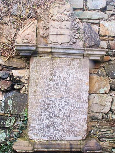
Remains of three-bay single-cell church, built c. 1550 and repaired and rebuilt c. 1620, and c. 1700. Now ruinous. Pitched roof, now removed\collapsed, having projecting eaves course to north and south, remains of stone coping to gable ends, and with rubble stone bellcote to the west gable end. Constructed of rubble stone masonry, formerly rendered, having small rubble stone pinnings. Two segmental-headed window openings to the south and north elevations, now blocked with rubble stone masonry, having rubble stone voussoirs over. Segmental-headed window opening to the east gable end, now blocked with rubble stone masonry, having rubble stone voussoirs over. Square-headed doorway to the west end of the south elevation having replacement lintel and segmental-headed relieving arch over with rubble stone voussoirs. Sections of plaster survive to interior walls. Memorial to William Wray, dated 1710, to interior comprising marble tablet (on rectangular-plan) with inscribed text, cornices to base and head, and surmounted by stone tablet with crest of the Wray family flanked to either side by upturn console brackets. Graveyard to site (on sub rectangular-plan) with collection of mainly eighteenth and nineteenth century upstanding and recumbent memorials, some with metal railed enclosures. Site surrounded by rubble stone boundary wall with fieldstone soldier coping over. Gateway to the south-west of site comprising a pair of rubble stone gate piers (on square-plan) having rubble stone coping over, and with wrought-iron flat bar gate. Located in the rural countryside to the south\south-east of Dunfanaghy. Modern graveyard to the west and group of graveyards (see 40901521) located adjacent to the east.
Appraisal
This attractive and poignant site is an interesting addition to the rural landscape to the south of Dunfanaghy. The simple rubble stone single-cell church, which probably originally dates to the sixteenth century and was described by a Royal Commission Report in 1622 as ‘newly re-edified and well repaired’, which suggests works here shortly prior to this date. It was originally in use as a Catholic church but was later in use as a Church of Ireland church from c. 1690 until the construction of the fine new church (see 40902615), St. John’s, at nearby Ballymore in 1752; it was abandoned shortly after this date and is depicted as ‘Church Ruins’ on the Taylor and Skinner map of the area, 1777-83, and as ‘Church (in ruins)’ on the Ordnance Survey first edition six-inch map of c. 1837. It is likely that this church was altered at some stage post 1700 perhaps c. 1710 when the fine memorial to William Wray of Ards Demesne was added to the interior. This classical-style memorial with intricate carvings of the Wray family crest, console brackets, and cornices is in contrast with the plain form of the church itself. There is some evidence of possible burning to the masonry to the north elevation and the south-west corner of the building. The graveyard to site contains a collection of mainly upstanding gravemarkers of eighteenth and nineteenth-century date, some of modest artistic interest. Some of the later graves have intricate cast-iron railings, which adds some additional interest. Site is of archaeological and social significance as early site of worship and burial. Amongst those buried here is a priest whose gravestone reads ‘Pray for the soul of Aenes Mac Bridge, who departed this life in 1776 AD’. The simple rubble stone boundary walls, and the gateway to the south-west corner with rubble stone piers, and wrought-iron gate add to the setting and context, and complete this composition.