

Survey Data
Reg No
40800301
Rating
Regional
Categories of Special Interest
Architectural, Technical
Previous Name
Rathmelton Mill
Original Use
Mill (water)
Date
1800 - 1815
Coordinates
221736, 421003
Date Recorded
09/06/2014
Date Updated
--/--/--
Description
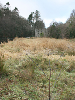
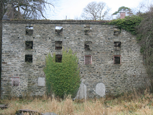
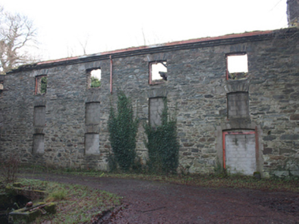
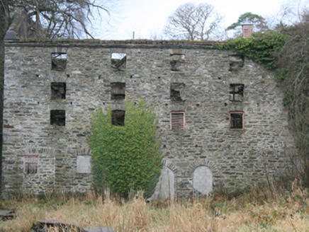
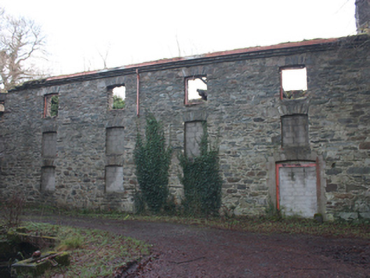
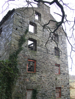
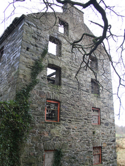
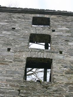
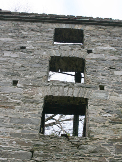
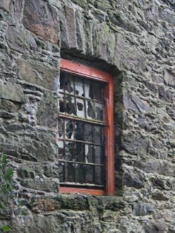
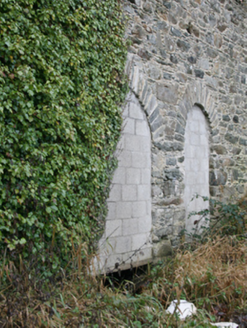
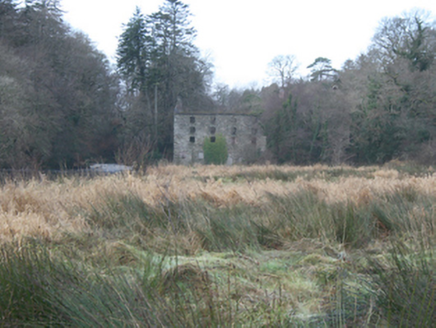
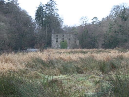
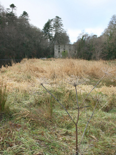
Detached five-bay three-storey over basement level former corn and flour mill with basement level and attic storey, built c. 1812 and altered c. 1875. Three-storey elevation to the west. Now out of use (burnt c. 1980). Formerly with pitched natural slate roof (now collapsed )having projecting stepped cut stone eaves course, raised rendered verges to the gables ends (north and south), roughcast rendered rubble stone chimneystack to the south gable end, and with some surviving sections of cast-iron rainwater goods. Rubble stone walls (galloped) with flush roughly dressed block-and-start quoins to the corners. Initials carved into some of the stonework (not viewed). Shallow segmental-headed window openings with rubble stone voussoirs, openings blocked-up or void of fenestration (remnants of timber frames and cast-iron window frames in some openings, and some surviving cast-iron window frames with bottom-hung inward-opening lights and timber frames. Timber louvered fittings to single window opening to the east elevation at ground floor level (basement level to east). Window fittings to majority of openings now removed; some ground floor openings now infilled with modern blockwork. Shallow segmental-headed door opening to the south end of the west elevation having rendered block-and-start surround; now infilled with modern blockwork; shallow segmental-headed door opening to the south end of the east elevation having roughly squared rubble stone voussoirs, now in filled with rubble stone masonry having inset square-headed window opening with cast-iron window. Two round-headed openings to the centre of the east elevation (formerly housing waterwheels or acting as exits for the tail race?), now infilled with modern blockwork, having roughly squared rubble stone voussoirs. Collapsed remnants of mill machinery to interior including waterwheels (not viewed, no access possible). Former headrace to the north-west and remains of tailrace to the south-east. Collapsed duck-board walkway to the west. Located in the rural countryside to the west of Ramelton town centre. Located on the north bank of Leannan River adjacent to the south-east of Drummonaghan Bridge (see 40800210) and former mill weir (see 40823002). Later mill buildings (see 40800302 and 40800302) directly to the north-west.
Appraisal
Although now sadly derelict, this imposing large-scale former flour mill complex retains its early form and stark industrial character, and is an important element of the extensive industrial heritage of the Ramelton area. It is robustly constructed using galleted rubble stone masonry, and its continued survival despite a long period of disuse is testament to the quality of the original construction. The building displays features common to its type and date, including relatively small window openings, and plain construction with little emphasis on embellishment. This is one of the few purpose-built merchant flour mills in this part of County Donegal, the majority of other mills were built to mill corn and oats for local use. Flour mills are usually on a much larger scale due to the need to have vast storage areas for meal, corn and flour, which is the case here at Drummonaghan or Bridge End. It originally dates to the start of the nineteenth century, which was a boom period for the Irish corn industry. It constitutes the earliest of a group of associated mill buildings at this site (see 40800302 and 40800303 for other structures). It was originally built by James Watt, who also constructed a fine residence called The Green (see 40800305) a short distance to the east of this site. The Ordnance Survey Memoirs of 1834 record that the mill was in the ownership of Mr. Watt at this time, and had an undershot waterwheel. It was later apparently purchased by the Kelly family in 1846 (James Watt of nearby Claragh House is listed as the owner of the mills in Slater’s Directory of 1846), although some sources suggest that in 1876 Edward Kelly, a former clerk in David Watt’s distillery in Derry, went into partnership with Watt, and subsequently took ownership of the mills (a Charles Kelly is recorded on a 1873 plaque of the neighbouring corn kiln - see 40800303). The mills were enlarged in 1873 with the construction of a new store (see 40800302) to site; it is likely that this earlier mill was upgraded around this time too, and cast-iron fittings to the openings may have been added at this time. It was in the ownership of Edward and Ellen Kelly in 1881, when it was known as Rathmelton Corn Mills. Large-scale early nineteenth-century mills were at the forefront of the industrialisation of food processing in Ireland, and this former mill building represents a good surviving example of its type from this period. Slater’s Directories of 1846 and 1881 record that around Ramelton ‘the trade in corn is considerable, and there are some large mills in the vicinity’. The mill was apparently highly successful, particularly due to its close proximity to the port at Ramelton, from where produce was exported (with the Clyde and Mersey areas particularly important destinations). The mill remained in use until 1972 when it finally closed. It was later sadly damaged in a fire c. 1980. Some of the machinery apparently survives to the interior (not viewed, no access possible). The mill was originally powered by a head race supplied by a weir (see 40823002) in the River Leanne a short distance to the north-west adjacent to Drummonaghan Bridge (see 40800210). From early cartographic information, the headrace appears to have been covered adjacent to the mill and powered a waterwheel or waterwheels to the interior of the building; the tailrace appears to have exited the building through the two now-blocked round-headed openings to the centre of the east elevation before discharging back into the river a short distance to the south-east. This imposing industrial building is of considerable social and economic significance to the local community, and would have employed a considerable work force in its heyday. In addition to representing the transition from the vernacular milling tradition to industrial mechanisation, this building stands as a symbol of the physical impact of large-scale industry on the rural landscape. This ruinous building is an interesting feature on the scenic rural landscape to the west of Ramelton, and is an integral element of the built heritage and extensive industrial archaeology of the local area. It forms part of a group of related structures along with the remains of the later former milling structures adjacent to the north-west (see 40800302 and 40800303), the weir (40823002) and bridge (40800210) to the north-west, and the headrace and tailrace.