


Survey Data
Reg No
40403909
Rating
Regional
Categories of Special Interest
Architectural, Artistic
Original Use
Farm house
Historical Use
Public house
In Use As
Farm house
Date
1800 - 1840
Coordinates
262009, 289448
Date Recorded
18/06/2012
Date Updated
--/--/--
Description
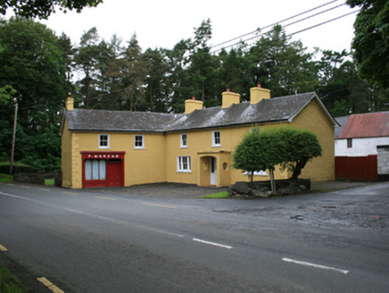
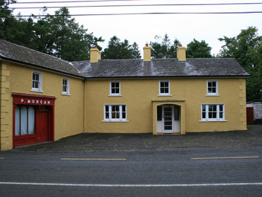
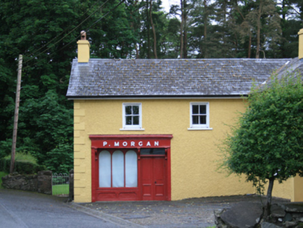
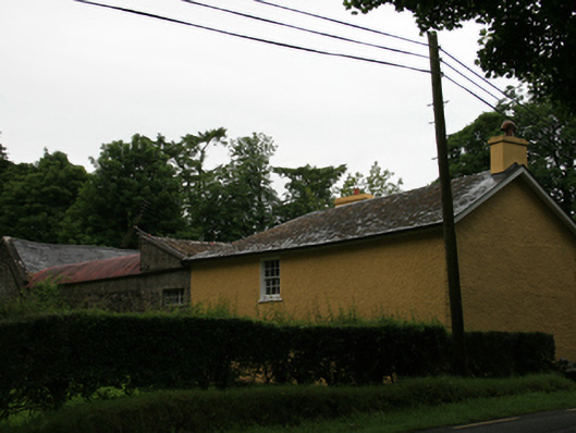
Detached L-plan multiple-bay two-storey farmhouse and attached public house, built c.1820, comprising three-bay main block with open porch of c.1960, perpendicular two-bay two-storey wing to south-east added c.1860 extending to roadside, with pub-front of c.1900. Recent lean-to extension to rear. Pitched slate roof hipped at corner, altered to have overhanging eaves and barges. Clay ridge tiles and and replacement aluminium rainwater goods. Pair of rendered chimneystacks flanking centre bay of main block, similar stack to former south gable, rendered chimneystack to roadside gable of wing. Roughcast rendered walls with smooth-rendered quoins to north end of main block and east end of wing, and patent reveals to window openings. Two-over-two sash windows to first floor, pair of square-headed tripartite windows to ground floor comprising one-over-one sash windows to sides and two-over-two to centre. Segmental-arch opening to porch with roundels to side walls, all with smooth render surrounds, square-headed door opening having fixed sidelights and replacement glazed timber door. Timber pub-front to north elevation of wing, comprising double-leaf panelled door with overlight and tripartite window with round-headed panes set over panelled render stallriser, flanked by plain timber piers, and surmounted by fascia with three supporting elongated brackets. Six-over-six timber sliding sash windows to ground and first floors of wing. Coursed rubble wall to north side of rear yard with square-profile masonry pier at north gable of house. Four-bay two-storey southern range of outbuildings with corrugated barrel-roof, two-bay two-storey rubble walled western range with pitched slate roof, and two-bay two-storey extension to north with corrugated roof and concrete barges, having latticed casement window and battened timber door to first floor. Single-storey lean-to northern range with corrugated barrel roof. Coursed rubble stone walls with piers to south of house with square-profile piers and cast-iron gate.
Appraisal
A prominent complex of buildings, located at a country crossroads and combining a mix of functions. It is likely that the main block of the house was built by 1820, suggested by the arrangement of the central chimneystacks. The building was probably enlarged and the outbuildings erected between 1840 and 1880. The presence of the public houses at the corner junction is of historic social importance. It is apparent from historic Ordnance Survey mapping that a smithy once stood on the opposite side of the road to the south and a dwelling once aligned the main road was located to the north, and together provide evidence of the former social and commercial importance of the road junction. Patrick Morgan is recorded in Griffith’s Valuation at this address, demonstrating a long-standing association of the Morgan name to these premises. The variety of outbuildings and their arrangement contribute to the building's setting and context, and the area's historic character.