
Survey Data
Reg No
31311125
Rating
Regional
Categories of Special Interest
Architectural, Technical
Previous Name
Castlemagarret House
Original Use
Bridge
In Use As
Bridge
Date
1700 - 1838
Coordinates
134962, 271291
Date Recorded
10/12/2010
Date Updated
--/--/--
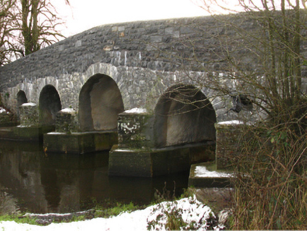
Description
Five-arch hump back road bridge over river, extant 1838. Disused, 2003. "Restored", 2009. Repointed walls centred on triangular cutwaters to piers to upriver (east) elevation on shuttered mass concrete battered bases with replacement parapets having hardcore gravel-encrusted rendered rounded coping. Series of five round arches with repointed voussoirs. Set in unkempt grounds shared with Castlemacgarrett spanning Robe River with overgrown banks to river.
Appraisal
A bridge contributing positively to the group and setting values of the Castlemacgarrett estate.