
Survey Data
Reg No
31307005
Rating
Regional
Categories of Special Interest
Architectural, Scientific, Technical
Original Use
Bridge
In Use As
Bridge
Date
1700 - 1838
Coordinates
119831, 293158
Date Recorded
18/11/2010
Date Updated
--/--/--
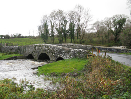
Description
Three-arch hump back road bridge over river, extant 1838. Part creeper- or ivy-covered repointed coursed or semi-coursed rubble limestone walls with lichen-covered rounded coping to parapets. Series of three segmental arches between flat iron "Serpentine" tie bars with cut-limestone voussoirs. Sited spanning Castlebar River with unkempt grass banks to river.
Appraisal
A bridge representing an integral component of the civil engineering heritage of Turlough with the architectural value of the composition suggested not only by the traditional construction in unrefined local fieldstone offset by limestone dressings demonstrating good quality workmanship, but also by the elegant "sweep" of the arches making a pleasing visual statement at a crossing over the Castlebar River: meanwhile, a discreet benchmark remains of additional interest for the connections with cartography and the preparation of maps by the Ordnance Survey (established 1824).