

Survey Data
Reg No
31306207
Rating
Regional
Categories of Special Interest
Architectural, Scientific, Technical
Original Use
Bridge
In Use As
Bridge
Date
1910 - 1920
Coordinates
144834, 300986
Date Recorded
06/11/2010
Date Updated
--/--/--
Description
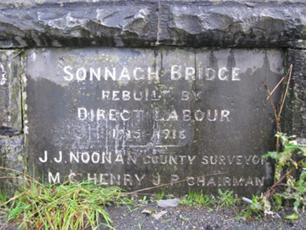
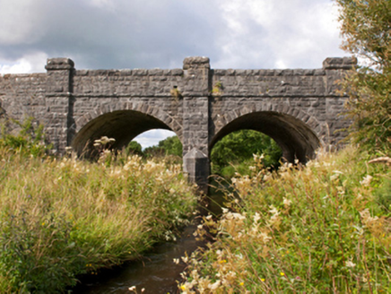
Two-arch road bridge over river, dated 1915-6; extant 1917. Tuck pointed snecked rock faced limestone walls between drag edged rock faced cut-limestone buttressed piers centred on tooled limestone ashlar triangular cutwater to pier to upriver (south) elevation having pyramidal capping with drag edged rock faced cut-limestone stringcourses supporting parapets having lichen-covered drag edged rock faced cut-limestone coping centred on benchmark-inscribed cut-limestone date stone ("1915-1916"). Pair of segmental arches with drag edged rock faced limestone ashlar voussoirs. Sited spanning Sonnagh River with unkempt grass banks to river.
Appraisal
A bridge erected to a design by John Joseph Noonan (b. 1879/80), County Surveyor for County Mayo North Riding (appointed 1911; dismissed 1921), representing an integral component of the early twentieth-century civil engineering heritage of the rural environs of Charlestown with the architectural value of the composition, one reconstructed 'by direct labour' retaining portions of an eighteenth-century bridge marked on the first edition of the Ordnance Survey (surveyed 1838; published 1839), confirmed not only by the robust rock faced surface finish demonstrating good quality workmanship, but also by the elegant "sweep" of the arches making a pleasing visual statement at a crossing over the Sonnagh River: meanwhile, a submerged benchmark remains of additional interest for the connections with cartography and the preparation of maps by the Ordnance Survey (established 1824).