
Survey Data
Reg No
31305907
Rating
Regional
Categories of Special Interest
Architectural, Scientific, Technical
Original Use
Bridge
In Use As
Bridge
Date
1809 - 1838
Coordinates
113868, 299147
Date Recorded
12/01/2011
Date Updated
--/--/--
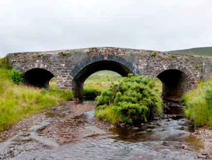
Description
Three-arch hump back road bridge over river, extant 1838. "Repaired". Part repointed coursed snecked sandstone walls with lichen-covered rendered rounded coping to parapets. Series of three segmental arches with sandstone ashlar voussoirs centred on drag edged tooled limestone ashlar voussoirs. Sited spanning river with unkempt banks to river.
Appraisal
A bridge identified as an integral component of the early nineteenth-century civil engineering heritage of County Mayo on account of the connections with the development of the so-called "Central Road" (1820-4) by William Bald (c.1789-1857), cartographer and engineer (appointed 1809), with the architectural value of the composition confirmed not only by the construction in a ruby-coloured sandstone offset by "sparrow pecked" sheer limestone dressings demonstrating good quality workmanship, but also by the elegant "sweep" of the arches making a pleasing visual statement at a crossing over a tributary of the Clydagh River: meanwhile, a discreet benchmark remains of additional interest for the connections with cartography and the preparation of maps by the Ordnance Survey (established 1824).