
Survey Data
Reg No
31302102
Rating
Regional
Categories of Special Interest
Architectural, Scientific, Technical
Original Use
Bridge
In Use As
Bridge
Date
1800 - 1838
Coordinates
112030, 325323
Date Recorded
07/03/2011
Date Updated
--/--/--
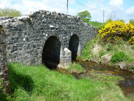
Description
Two-arch hump back road bridge over river, extant 1838. Tuck pointed coursed or snecked limestone walls centred on triangular cutwater to pier having pyramidal capping with lichen-covered rock faced hammered limestone coping to parapets. Pair of round arches with limestone ashlar voussoirs. Sited spanning Pollrabeen or Fiddaunculleen River with unkempt banks to river.
Appraisal
A bridge representing an integral component of the civil engineering heritage of County Mayo: meanwhile, a discreet benchmark remains of additional interest for the connections with cartography and the preparation of maps by the Ordnance Survey (established 1824).