
Survey Data
Reg No
31300301
Rating
Regional
Categories of Special Interest
Architectural, Historical, Social, Technical
Original Use
Building misc
Date
1939 - 1942
Coordinates
69802, 340908
Date Recorded
21/05/2013
Date Updated
--/--/--
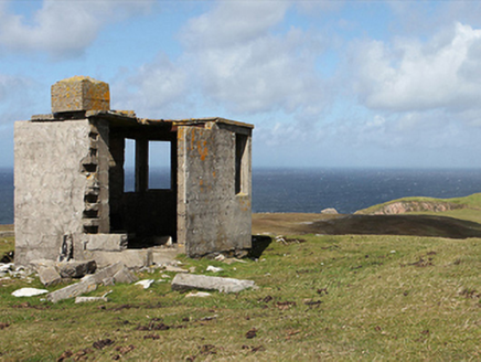
Description
Freestanding single-bay single-storey flat-roofed lookout post ["LOP"], between 1939-42, on an elongated half-octagonal plan. Now in ruins. Remains of flat reinforced concrete roof with mass concrete central chimney stack. Rendered or fine roughcast mass- or reinforced concrete block walls. Square-headed window openings with no fittings surviving. Set in unkempt grounds on headland.
Appraisal
A lookout post ["LOP 62"] erected during "The Emergency" (1939-46) to a standardised design signed by William Henry Howard Cooke (1881-1977) of the Office of Public Works (established 1831) representing an important component of the mid twentieth-century built heritage of Contae Mhaigh Eo [north County Mayo] (cf. 31300101; 31300706; 31300801; 31305303; 31307501; 31308503). NOTE: A so-called "Éire Marking" survives nearby (coordinates 469659,840897).