

Survey Data
Reg No
15701305
Rating
Regional
Categories of Special Interest
Architectural, Scientific, Technical
Original Use
Bridge
In Use As
Bridge
Date
1700 - 1840
Coordinates
284912, 145808
Date Recorded
27/08/2007
Date Updated
--/--/--
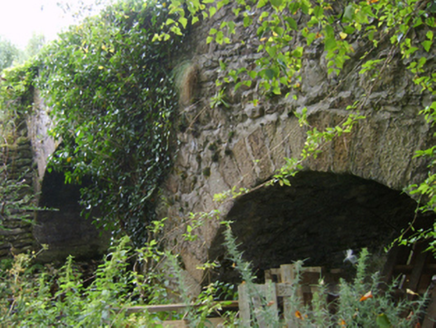
Description
Two-arch hump back road bridge over stream, extant 1840. Part creeper- or ivy-covered walls with overgrown coping to parapets. Pair of round or segmental arches with repointed granite ashlar voussoirs. Sited spanning Asinvillar Stream with unkempt banks to stream.
Appraisal
A bridge representing an integral component of the civil engineering heritage of the environs of Kiltealy: meanwhile, a much weathered benchmark remains of additional interest for the connections with cartography and the preparation of maps by the Ordnance Survey (established 1824).