
Survey Data
Reg No
14006014
Rating
Regional
Categories of Special Interest
Artistic, Social
Previous Name
Navan Barracks
Original Use
Ordnance stone/marker
Date
1830 - 1855
Coordinates
286955, 268028
Date Recorded
14/09/2005
Date Updated
--/--/--
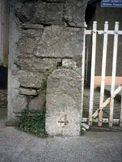
Description
Freestanding inscribed cut-stone boundary stone, c.1840. Road fronted on concrete footpath. NOTE: The boundary stone is inscribed "BO/↑/4" and is the last of a set of six boundary stones originally marking the boundary of the Board of Ordnance-owned Navan Barracks. The positions of the boundary stones are shown on "NAVAN BARRACKS COUNTY OF MEATH" (1866) and, clockwise, included "BO/↑/1" near the north-east corner of the site; "BO/↑/2" and "BO/↑/3" on the east flank of the site; the surviving "BO/↑/4" at the south-east corner of the site; "BO/↑/5" at the south-west corner of the site and "BO/↑/6" at the north-west corner of the site [Military Archives of Ireland AD134730-005]. Navan Barracks was erected (1702) on the site of Saint Mary's Augustinian Abbey [SMR ME02-024----] and was 'adapted for 4 officers and 52 non-commissioned officers and privates, with stabling for 50 horses' (Lewis 1837 II, 421). The vacant Navan Barracks was sold (29th November 1912) to Navan Urban District Council [Military Archives of Ireland AD119302-009] and was subsequently adapted as Abbey School (1917-57).