


Survey Data
Reg No
13402612
Rating
Regional
Categories of Special Interest
Architectural, Historical, Social, Technical
Original Use
Mill (water)
Date
1800 - 1840
Coordinates
213521, 255919
Date Recorded
11/08/2005
Date Updated
--/--/--
Description
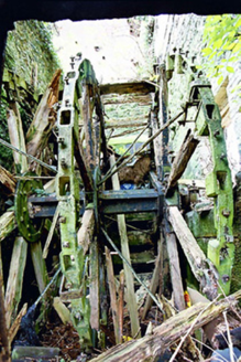
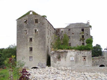
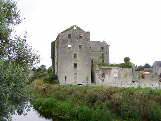
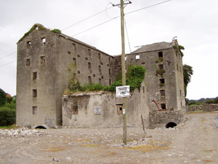
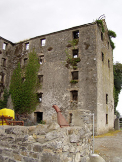
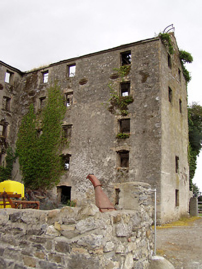
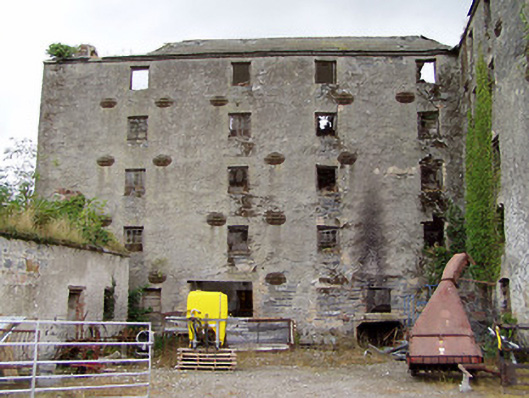
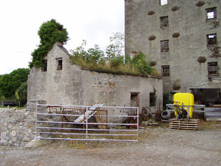
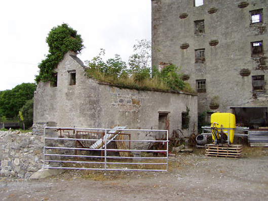
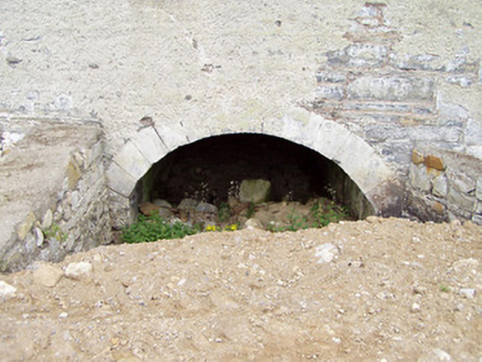
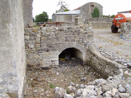
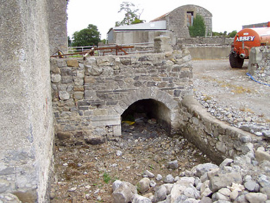
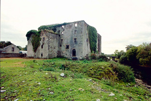
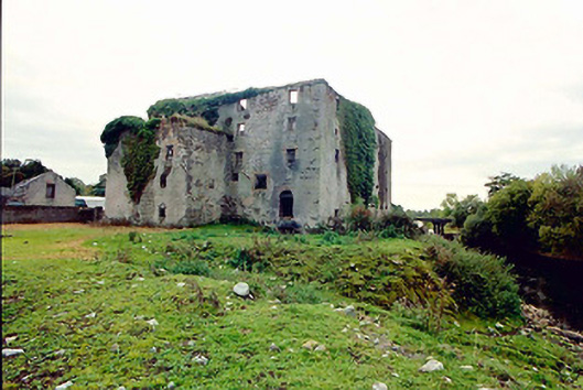
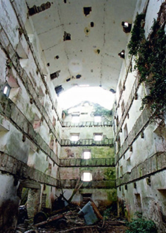
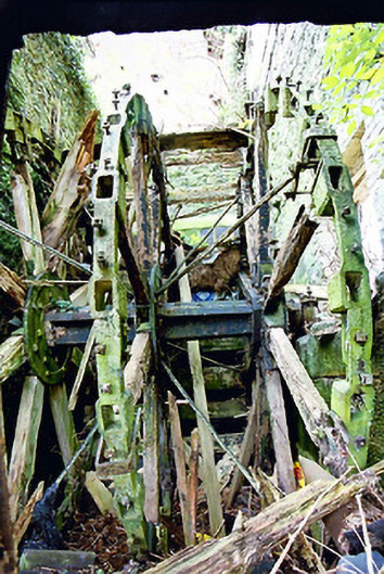
Detached multiple-bay five-storey former corn and flour mill, and stores, on L-shaped plan with, built c. 1800 and extended c. 1850, having attached four-storey former corn kiln to the north elevation and detached three-bay single-storey former office building to the south. Now ruinous and out of use; internal floors now collapsed. Remains of hipped and pitched natural slate roofs with cut stone eaves course. Roughcast rendered walls over coursed rubble stone and rubble stone construction. Flush dressed limestone block-and-start quoins to the corners of the five-storey block to the south (south end). Cast-iron wall ties/pattrice plates to walls. Square-headed openings some with remains of some six-over-three pane timber sliding sash windows; majority of windows and frames now removed. Square-headed doorways to east elevation. Brick surrounds and voussoirs evident to a number of window and door openings. Round-headed arched openings to former millraces to the south gable end of block to south, to the north elevation, and to the east side of former office building to southeast having dressed limestone voussoirs. Round-headed opening to gable apex of range to south. Remains of former breast-shot millwheel to the west end of block to north having cast-iron axle and rings with timber spokes and remains of timber floats. Set back from road in own grounds on the east bank of the River Inny with remains of weir to the north. Brick vaulting and former ovens to former drying kiln to the north elevation. Single-storey former outbuilding to the northeast. Ruinous three-storey former corn mill located across the Inny to the west having rubble stone walls and square-headed openings.
Appraisal
This large-scale former corn and flour mill complex is one of the most significant elements of the industrial heritage of County Longford. Although now derelict with roof collapsing and floors removed, the buildings retain their early form and stark industrial character. This is one of the few (possibly the only) purpose-built merchant flour mills in County Longford, the majority of other complex were built to mill corn and oats for local use. Flour mills are usually on a much larger scale due to the need to have vast storage areas for meal, corn and flour. It probably originally dates to the late-eighteenth or very early-nineteenth century, which was a boom period for the Irish corn/oat milling industry. However, the complex appears to have been extended c. 1850, when the five-storey block to the south end of the L-plan main structure was built (not depicted on Ordnance Survey first edition map 1838; according to local information there is a date stone dated ‘1847’ to site, not located). This section may have been built to provide additional storage area. The round-headed opening to the gable apex of this probable former store may have formerly held a bell. The four-storey former grain drying kiln to the north, which has a brick vaulted ceiling to the ground floor and the remains of ovens, and the small office/administration building to the southeast, may also have been added c. 1850. The remains of the former millwheel (16ft in diameter) to the block to the north is an interesting survival that provides an interesting historical insight into past industrial processes and is of technical merit. The arched openings to the former head and tail races are also of technical merit. This mill/land was described as the property of Councillor Henderson c. 1835 (O’Donovan Letters). Lewis (1837) records ‘near the bridge of Shrule, but in the parish of Noughaval, are flour-mills producing annually about 4000 barrels of flour’. It was later run by Michael Murtagh, leased from Wm Henderson, c. 1855, when the site was described as consisting of ‘house, offices, flour mill and kiln’ and had a ratable value of £80 (Griffith’s Valuation). It was later in the ownership of a Matthew Fegan in 1881 and 1894 (Slater’s Directories). It closed down in the early 1900s. The three-storey former corn mill on the opposite bank of the Rover Inny was in the ownership of a Philip McGlynn c. 1855, when it had two 11ft wheels powering two sets of stones (Valuation Office Mill Book). It is interesting that there were two large mills in such close proximity, which indicates that this was a location along the Inny that had the capacity to produce a significant amount of water power. The five-storey mill has interesting historical associations with the noted poet and nationalist John Keegan Casey ‘Leo’ (1846 – 1870), one of the central figures in the Fenian Rising of 1867, who worked as a clerk at the mill sometime during the 1860s. Although this complex is now out of use, it remains an important element of the industrial and economic history of the area, and creates historic incident in the rural landscape to the southwest of Ballymahon.