
Survey Data
Reg No
12306003
Rating
Regional
Categories of Special Interest
Architectural, Artistic
Original Use
Gates/railings/walls
In Use As
Unknown
Date
1715 - 1735
Coordinates
266578, 159713
Date Recorded
16/07/2004
Date Updated
--/--/--
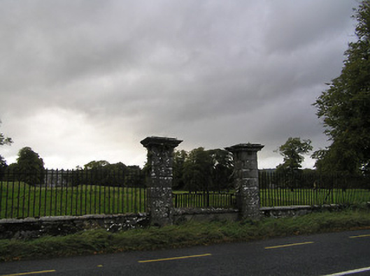
Description
Gateway, c.1725, comprising pair of rusticated limestone ashlar piers with moulded cornice capping, and sections of iron flanking railings on random rubble stone plinths having cut-stone coping. Renovated, post-1840, with unpainted rendered plinth inserted over random rubble stone construction having cut-stone coping supporting decorative wrought iron panel to accommodate use as "Claire Voie". Road fronted at entrance to grounds of Shankill Castle with random rubble stone boundary wall to perimeter of site.
Appraisal
Originally marking the midway point of an avenue or axis between Shankill Castle (12306002/KK-01-06-02) and a monument or statue (pre-1840; demolished, pre-1902) identified on archival editions of the Ordnance Survey an elegantly-composed Classically-detailed gateway displaying high quality stone masonry makes a pleasing visual statement in the local landscape. Retained in a modified incarnation as a gesture representing the meeting of the architectural and natural or landscape realms of the Shankill Castle estate the "Claire Voie" now features an elaborate screen in iron contributing significantly to the aesthetic value of the composition.