
Survey Data
Reg No
11207002
Rating
Regional
Categories of Special Interest
Scientific
Original Use
Bridge
In Use As
Bridge
Date
1845 - 1850
Coordinates
298388, 231164
Date Recorded
05/06/2002
Date Updated
--/--/--
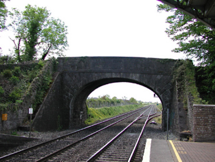
Description
Archival Description [Demolished 2008]: Single-arch bridge over railway line, opened 1846. Part ivy-covered snecked limestone walls between snecked limestone battered abutment walls with cut-limestone stringcourses supporting benchmark-inscribed parapets having cut-limestone coping. Single elliptical arch with margined rock faced limestone ashlar radiating voussoirs. Sited spanning railway line with unkempt banks to railway line.
Appraisal
Archival Appraisal [Demolished 2008]: A bridge identified as an integral component of the mid nineteenth-century civil engineering heritage of south County Dublin on account of the connections with the development of the Great Southern and Western Railway (GSWR) line opened (1846) by the Great Southern and Western Railway (GSWR) Company with the architectural value of the composition suggested not only by the rock faced dressings demonstrating good quality workmanship, but also by the elegant "sweep" of the arch making a pleasing visual statement at a crossing over the railway line: meanwhile, a discreet benchmark remains of additional interest for the connections with cartography and the preparation of maps by the Ordnance Survey (established 1824).