Minor Harbours of Ireland, an Irish Research Council-funded project by UCD School of Architecture, Planning and Environmental Policy, examines the evolution of maritime engineering in small harbours along the east coast of Ireland from the seventeenth century to the present. The results of the project will be made publically accessible on the UCD Digital Library site in the autumn. In the following Building of the Month, which has been given the title “A Harbour Built for One: Fethard Quay, County Wexford”, Dr. Elizabeth Shotton previews the project by recounting the history of a harbour described as Ireland’s smallest harbour.
Figure 1: LiDAR scan of Fethard Quay, County Wexford, made in 2016 with the ruins on the Lynn warehouses on the left. The harbour was surveyed as part of the UCD School of Architecture, Planning and Environmental Policy Minor Harbours of Ireland project funded by the Irish Research Council (Shotton, Semar, Lennon 2016)
Described as Ireland’s smallest harbour (Hassard 1923), the diminutive Fethard Quay at Ingard Point, east of the town of Fethard in County Wexford, is one of the oldest harbours on Ireland’s east coast that is still largely intact in its original form (fig. 1). The harbour is approximately 30 meters in width by 60 meters in length, consisting of a quay and two piers, one L-shaped, in addition to slipways outside the structure on each side, the eastern slipway being a more recent addition. There had also been a watch house on the smaller west pier, later removed, in addition to private warehouses on the quay owned by the local Lynn family. Although Fethard has supported a fishing community since at least the seventeenth century (Hore 1859), using the small creek as a haven in the first instance and, since at least 1798, finding shelter in this small harbour, Fethard Quay had never been intended as a haven for fishing boats but rather was purpose-built to harbour a single vessel, the King’s Barge.
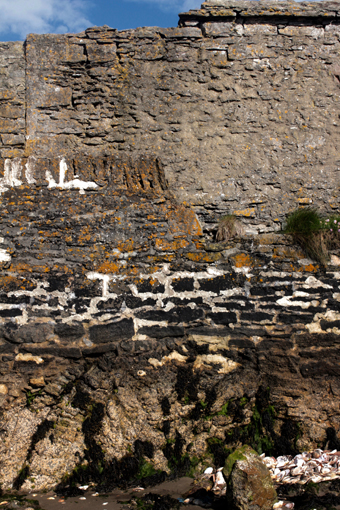
Figure 2: A detail of the exterior face of the west pier showing the remnants of vertical coping on the left and the last remaining wall of the watch house on the right (Shotton 2016) |
The building of Fethard Quay was driven by the need for a safe haven from which a revenue cruiser could operate along the coast for the Commissioners of Customs, known locally as the Commissioners of Revenue. Revenue cruisers, occasionally referred to as a King’s Barge (Frizell 1771; Moylan 1960), were responsible for policing smuggling activities and the one planned for Fethard was but one of many operating along the coasts of Ireland. Fethard Quay was commissioned and purpose-built for the Commissioners in 1741 by Nicholas Loftus (c.1687-1763), then landlord of Fethard as well as much of the Hook peninsula, for which he received £200 in payment (Irish 1741-42). Built principally of partially squared, roughly coursed limestone (Stanley 2016), which is not found in this area, in addition to some amount of old red sandstone that is local (Kinahan 1885-89), it is probable that the limestone was shipped from the Loftus harbour in Slade, further south on the Hook peninsula, where there was an abundance of limestone quarries. It is also possible that workmen from Slade built the harbour as traces of vertically-set stone coping can still be seen in part of the west pier (fig. 2), a style used in the neighbourhood of Slade but nowhere else on the peninsula (Colfer 2010). |
Figure 3: The pier heads (Shotton 2016)
There is some ambiguity in the archival record as to whether the original construction included both piers or only the more substantial L-shaped pier. Although construction of both is broadly similar, particularly at the pier heads (fig. 3), there are references that may suggest that the smaller west pier is of a slightly later date. A description by Dr. Pococke from his tour of Ireland in 1752 refers to the newly constructed harbour as a “mole” ‘in which a vessel of an hundred tun can lye safe [sic]’ (Stokes 1891). Mole, a word in common use until the eighteenth century, typically referred to a single structure such as a breakwater, rather than a set of piers enclosing a harbour. While it is possible that Pococke was using the term unadvisedly, in Murdoch McKenzie’s survey of the Irish coast (1758-1768), shortly after Pococke’s tour, the harbour at Ingard Point is drawn as a single structure rather than a pair of piers (fig. 4). Yet, in the directions intended to accompanying these charts, MacKenzie describes the depth of water between the pier-heads (Mackenzie 1776b), indicating both piers were extant despite the ambiguous illustration on the chart. The survey of the Loftus estate on the Hook Peninsula of 1771 by Richard Frizell offers little by way of clarification as the harbour at Ingard point is outlined rather than drawn in detail (fig. 5).
.jpg) |
.jpg) |
Figures 4-5: Ingard Point and Fethard Quay as illustrated in Murdoch McKenzie’s survey of the Irish coast (1758-1768) and Richard Frizell’s survey of the Loftus estate on the Hook Peninsula (1771). Figure 4 reproduced with permission of the Royal Geographical Society (MR 14.C.50 (0) Chart 2) and Figure 5 reproduced with permission from the National Library of Ireland (MS 4153)
Although the ambiguity of these early references could be dismissed, when coupled with a much later reference that described the west pier as having been built for the Coastguard in 1774 (Admiralty 1911) and that they had possession of the west pier and watch house from 1777 by leave of the Commissioners of Revenue (Admiralty 1914), some reasonable doubt emerges. A date of construction of 1774 could resolve the disparity between Mackenzie’s chart, drawn earlier than 1774, and the description of the harbour published in 1776. Close examination of the seaward face of this pier does suggest that as first built the pier had a much lower parapet wall finished with vertical stone work and that the watch house and raising of the parapet level were undertaken at a later date (fig. 2). Based on the later evidence from the Admiralty and the on-site surveys, while it is possible that the west pier was built later than the L-shaped pier, it is seems more certain that the construction of the watch house was undertaken between 1774 and 1777.
Following the grant of the smaller pier to the Coastguard and the building of a watch house, additional private warehousing was also built on the quay by the Lynn family (Cloney 1994). Although the date of construction is uncertain, they were extant in 1798 when, in what has been described as one of the few naval gun battles between Irish Rebels and the British Navy during the Rebellion, extensive damage was done to the warehouses (never repaired) as well as the destruction of 13 fishing vessels (Anon. 1798). The watch house also sustained damage during this battle, which was repaired by the Commissioners in 1799 for £122 (Irish 1799; Irish 1800a), followed by minor repairs to the piers the next year at a cost £57 (Irish 1800b), which may have included raising the parapet on the west quay.
The Commissioners maintained an uninterrupted presence at Fethard Quay at least until 1824 (Anon. 1824) save for a short gap between 1770 and 1773 when they moved both the revenue barge and the men to Whitehouse Bay on the western side of the Hook peninsula to operate in the quarantine service for Waterford Harbour (Irish 1770). A renewal of smuggling activity on the coast between Slade and Fethard brought the men back, with a new 32 foot cruiser built on their return (Irish 1773). The Commissioners appear to have ceased using Fethard as a station by 1833 (Anon. 1835) but nevertheless retained ownership of the entire structure until 1856 when ownership of the west pier and watch house was vested with the Admiralty under the Coast Guard Service Act of 29th July 1856 (Admiralty 1914). While it is unclear when the Commissioners relinquished ownership of the main pier, following the 1898 act that established local county councils the pier was in the ownership of Wexford County Council. The Admiralty retained ownership of the west pier and watch house until the early twentieth century when an outbreak of Scarlatina among the coastguard staff resulted in the closing of the station and the selling of the pier and watch house to Wexford County Council for a nominal sum of £5 in 1914.
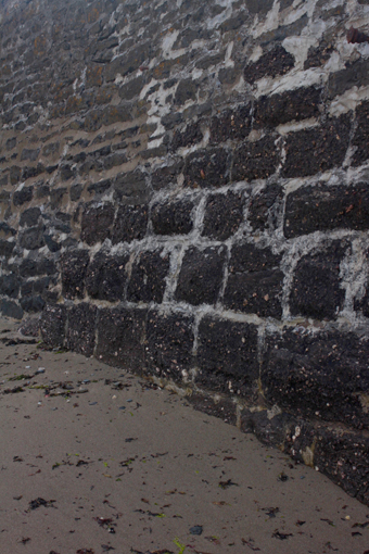
Figure 6: A detail of the red sandstone conglomerate on the seaward face of the main pier possibly dating to 1849 (Shotton 2016) |
The continued ownership of Fethard Quay by the Commissioners in the nineteenth century complicated repeated petitions to the Board of Public Works from the fishing community, as the Board had no jurisdiction over the harbour (Board 1822-54), thus the earliest petition for a new pier at Fethard in 1846 was refused (Board 1846-49; Chief 1846). A more limited case for repairs made in 1849 (Board 1846-49), sponsored by a letter from the Chief Officer of the Coastguard Station that described the dilapidated state of the pier at Fethard following storm damage (Board 1846-49; Board 1846-83), received a more positive response despite the complications in jurisdiction. These minor repairs were undertaken in 1849 by the contractor Pat Maher under the direction of the engineer Barry Gibbons (Board 1846-83) at a cost of £63 (Board 1846-49). Although not described in the documents, the repairs may have been to the exterior of the east pier using red sandstone conglomerate (fig. 6) as Maher described finding a source for this stone, intended for use at Kilmore (Public 1849), while completing work on the nearby harbour of Slade in 1848 (Board 1822-54). The stone work in this section of the pier is substantially different in size, form and coursing from the remainder of the pier, and so similar to the stone work in Kilmore, undertaken just after the minor repairs at Fethard were completed, that it appears probable that Maher was responsible for this work. |
.jpg)
Figure 7: A sketch proposal for a new concrete pier at Fethard Quay from the Wexford County Council Minute Books 1903. Reproduced with permission from Wexford County Archive WXCC 1/1
Petitions for a new pier by the fishing community continued unabated through the nineteenth and twentieth centuries, although all were ultimately unsuccessful. The most ambitious proposal was for a concrete pier in 1903 (fig. 7) that would have seen a new pier extend into deeper waters from the seaward face of the main pier. Although debated for some time it was ultimately refused due to the anticipated cost, variously estimated between £5000 and £12,000 (Wexford 1907-09). Applications for minor improvements were generally more successful, resulting in a series of limited alterations in the twentieth century by Wexford County Council, including the rebuilding of the back wall of the harbour to alter its alignment with the west pier and the addition of a concrete platform at the south west corner of the harbour interior to facilitate access past the watch house to the west pier (Wexford 1912, 1928). The watch house, built in such a manner as to limit access to the west pier except through the building itself, had continued to present problems for the County Council, leading to its truncation in 1978 (fig. 8) and ultimately its complete removal in 2007 (Wexford 1978). A further addition of a broad stairway followed in 1988 (Wexford 1988) while repairs in concrete to the seaward face of the L-shaped pier were made in 1990 following storm damage (Wexford 1990).
.jpg)
Figure 8: The truncated remains of the watch house on the west pier photographed in 2007. The original extent of the watch house is indicated by the pilaster on the right of the photograph. Reproduced with permission from Wexford County Council
The lack of success in obtaining a larger pier to support the fishery at Fethard, although likely frustrating to the local fishing community, has ensured that this very unique harbour has remained largely intact in its original form, standing as a testament to the building skills of the eighteenth-century masons responsible for its construction. A recent LiDAR-based survey of Fethard Quay, which produced a full-scale three-dimensional point cloud model of the harbour (fig. 9), has ensured that this remarkable harbour is properly documented for future research. This model, in addition to several other minor harbours on Ireland’s east coast, will be made publically accessible on the UCD Digital Library site, under Minor Harbours of Ireland, in the autumn of 2017.
.jpg)
Figure 9: LiDAR scan of Fethard Quay, County Wexford, from the basin of the harbour looking toward the pier heads. The harbour was surveyed as part of the UCD School of Architecture, Planning and Environmental Policy Minor Harbours of Ireland project funded by the Irish Research Council (Shotton, Semar, Lennon 2016)
Dr. Elizabeth Shotton is currently Director of Research, Innovation and Impact in UCD School of Architecture, Planning and Environmental Policy. She teaches in construction technology and design studio, with an emphasis on sustainable building and development, at both undergraduate and graduate level. She holds undergraduate degrees in Commerce and Architecture as well as a PhD in Architecture from UCD. Elizabeth also works in the field of construction history and is principal investigator of Minor Harbours of Ireland, an Irish Research Council-funded project examining the evolution of maritime engineering in small harbours along the east coast of Ireland from the seventeenth century to the present
BIBLIOGRAPHY
Primary Sources
Admiralty, UK. [1911]. “Disposal of Unused Coast Guard Premises at Fethard, Co. Wexford” Folio No. T1/11290/8735. The National Archives UK
Admiralty, UK. [1914]. “Fethard (Ireland) Abolition of Coast Guard Station” Folio No. ADM 116/1366. The National Archives UK
Board of Public Works. 1822-54. Slade Harbour. OPW 8/337/3. National Archives of Ireland
Board of Public Works. 1846-49. Piers and Harbours Letterbooks. OPW 1/8/2/2. National Archives of Ireland
Board of Public Works. 1846-83. Fethard Pier. OPW 8/144. National Archives of Ireland
Board of Trade. 1911. Fethard Harbour. MT 10/1400/13. The National Archives UK
Chief Secretary’s Office. 1846. CSO OP/1846 /152. National Archives of Ireland
Frizell, Richard. 1771. “Maps of the Lordships and Manors of Loftus Hall, Fethard and Templetown in the County of Wexford the Estate of the Right Honourable Henry Lord Viscount Loftus of Ely August 1st 1771” Maps. MS 4153 (020). National Library Ireland, 1771
Irish Revenue. 1741-42. Irish Revenue Board and Irish Board of Customs. Minute Books CUST 1/33. The National Archives UK
Irish Revenue. 1770. Irish Revenue Board and Irish Board of Customs. Minute Books CUST 1/115. The National Archives UK
Irish Revenue. 1773. Irish Revenue Board and Irish Board of Customs. Minute Books CUST 1/123. The National Archives UK
Irish Revenue. 1799. Irish Revenue Board and Irish Board of Customs. Minute Books CUST 1/264. The National Archives UK
Irish Revenue. 1800a. Irish Revenue Board and Irish Board of Customs. Minute Books CUST 1/268. The National Archives UK
Irish Revenue. 1800b. Irish Revenue Board and Irish Board of Customs. Minute Books CUST 1/272. The National Archives UK
Stanley, G., Geological Survey Ireland. 2016. Fethard Quay Site Inspection. Surveyed with: Shotton, E. Minor Harbours of Ireland
Wexford County Council. 1903. WCC Minute Books. WXCC1/1. Wexford: Wexford County Archives
Wexford County Council. 1907-09, 1912, 1928, 1937 1978 1988, 1990. WCC Minute Books. WXCC1/3, WXCC1/4, WXCC1/13, WXCC1/22, WXCC1/66, WXCC1/76, WXCC1/78. Wexford: Wexford County Archives
Secondary Sources
Anon. 1798. “Thursday June 14: Extract of Letter from Waterford” Belfast Newsletter
Anon. 1824. “Tenth Report of the Commissioners of Inquiry into the Collection and Management of the Revenue Arising in Ireland, Scotland &C. Ports of Ireland, Preventive Coast Guard, Quarantine, &c.”, 383 pages. London: House of Commons
Colfer, B. 2004. The Hook Peninsula. Cork: Cork University Press
Colfer, Niall. 2010. “Between the Sea and the Land: Coastal Limestone Quarries on the Hook Peninsula, Co. Wexford” The Journal of Irish Archaeology 19: 113-30
Cloney, S. 1994 – 1995. “South-West Wexford in 1798” Wexford Historical Society Journal
Hassard, Arthur. 1923. “Notes on the Dredging of Fishery and Other Small Harbours on the East Coast of Ireland” Transactions of the Institution of Civil Engineers of Ireland. Vol. 48
Hore, Herbert F. 1859. “A Chorographic Account of the Southern Part of the County of Wexford, Written Anno 1684: By Robert Leigh, Esq., of Rosegarland, in That County. (Concluded) ” The Journal of the Kilkenny and South-East of Ireland Archaeological Society. Vol.2, no. 2: 451-67
Hore, P.H. 1904. History of the Town and County of Wexford: Duncannon Fort, Kilglogan or Templetown, Fethard, Houseland, Portersgate, Loftus Hall, Galgystown, Hook [Including Churchtown], Slade, Baginbun, and Bannow. From the Earliest Period to the Present Time. 6 vols. Vol. 4, London: Elliot Stock
Kinahan, G. H. 1885-89. “Economic Geology of Ireland” Journal of the Royal Geological Society of Ireland. Vol. XVIII (Vol. VIII New Series). Special Issue
MacKenzie, Murdoch. 1776a. “The Survey of Ireland” In A Maritime Survey of Ireland and the West of Great Britain taken by order of the Right Honourable the Lords Commissioners of Admiralty in two volumes. Vol. 1. London: Royal Geographical Society, Call No. mr 14.C.50 [0]. Sea Charts. Chart 2
Mackenzie the Elder, Murdoch. 1776b. Nautical Descriptions of the Coasts of Ireland. London. Royal Geographical Society, Call No. N07/30U. Book
Moylan, T. K. 1960. The Peninsula of Portrane: Part I. Dublin Historical Record, Vol. 16, No. 1: 22-33
Public Works, Ireland. 1849. Seventeenth Report from the Board of Public Works, Ireland, with appendices. Command Papers: Reports Of Commissioners London: William Clowes and Sons
Stokes, George T., ed. 1891. Pocoke‘s Tour in Ireland in 1752. Dublin, London: Hodges, Figgis, And Co., Simpkin, Marshall, Hamilton, Kent and Co.
Back to Building of the Month Archive