
Survey Data
Reg No
15402318
Rating
Regional
Categories of Special Interest
Architectural, Cultural, Social
Original Use
Folly
In Use As
Folly
Date
1765 - 1775
Coordinates
211345, 247552
Date Recorded
11/11/2004
Date Updated
--/--/--
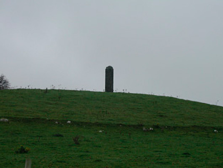
Description
Freestanding pillar/monument/folly on circular plan and c. five metres in height, dated 1769. Built in rubble limestone with projecting cut stone band at a high level and a shallow domed rubble limestone cap over. Cut stone date stone incised ‘1769’. Located two miles to the east of Glassan on a hilltop with panoramic views over the local countryside.
Appraisal
This unusual and enigmatic feature in the rural landscape of Kilkenny West, which dominates the local countryside, adding incident to the skyline. The original purpose of this structure is unknown but it was presumably originally associated with a demesne or, perhaps, as a navigation aid given its location overlooking Lough Ree to the west. Due to very obvious location in the landscape, this monument has always aroused interest as to its original origins and function. Numerous suggestions exist local as to its original function, ranging from the suggestion that it was the starting point and finishing point of a late eighteenth-century steeplechase known as the Kilkenny West race to the theory that it was built to mark the geographic centre of Ireland. One of the more popular theories is that it was originally built by the landlord Nathaniel Lowe as a tower to allow him to see land he owned at Kilkenny West from his country seat in Galway, some 30 miles to the west. Regardless of its intended original function, this structure is an important part of the built heritage, history and folklore of the local area.