
Survey Data
Reg No
31216004
Rating
Regional
Categories of Special Interest
Architectural, Scientific, Technical
Original Use
Bridge
In Use As
Bridge
Date
1850 - 1855
Coordinates
114854, 255285
Date Recorded
03/12/2010
Date Updated
--/--/--
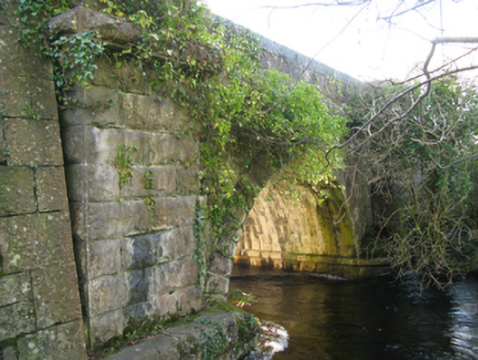
Description
Single-arch road bridge over river, built 1852; extant 1894. Part creeper- or ivy-covered tuck pointed coursed or snecked limestone walls between drag edged rock faced limestone ashlar battered piers with drag edged rock faced cut-limestone stringcourses supporting parapets having tooled cut-limestone rounded coping. Single round arch with drag edged rock faced limestone ashlar voussoirs. Sited spanning Cong River with unkempt banks to river.
Appraisal
A bridge identified as an integral component of the mid nineteenth-century civil engineering heritage of south County Mayo with the architectural value of the composition, one erected in connection with the development of the ill-fated Cong Canal (begun 1848; abandoned 1856), confirmed not only by the rock faced dressings demonstrating good quality workmanship, but also by the elegant "sweep" of the arch making a pleasing visual statement at a crossing over the Cong River: meanwhile, a benchmark remains of additional interest for the connections with cartography and the preparation of maps by the Ordnance Survey (established 1824).