


Survey Data
Reg No
40834001
Rating
Regional
Categories of Special Interest
Archaeological, Architectural, Artistic, Historical, Social
Original Use
Country house
In Use As
Country house
Date
1600 - 1860
Coordinates
231347, 400257
Date Recorded
19/01/2011
Date Updated
--/--/--
Description
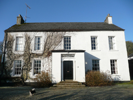
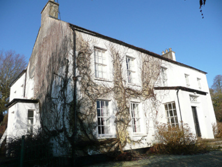
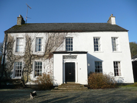
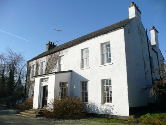
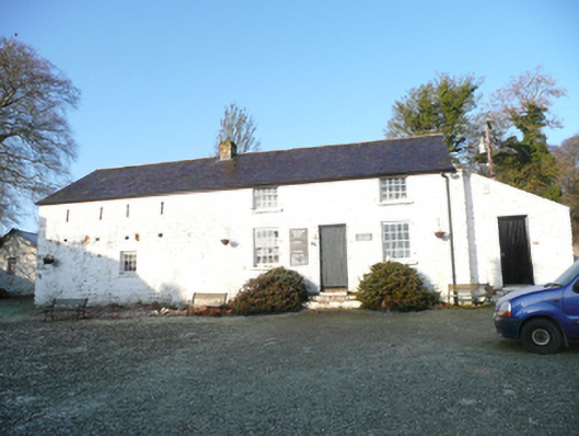
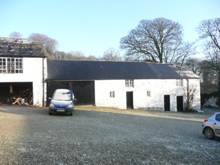
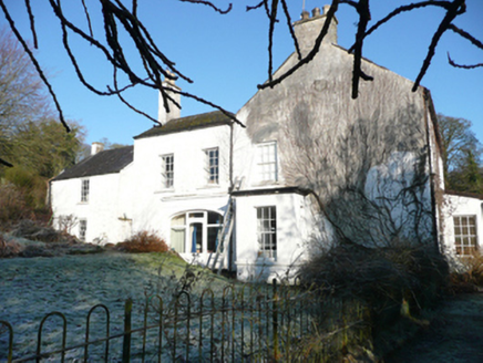
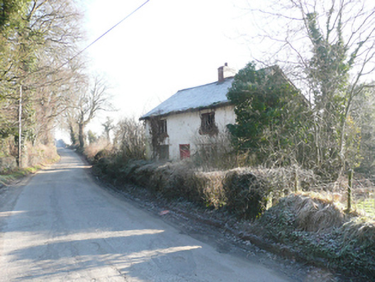
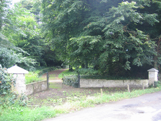
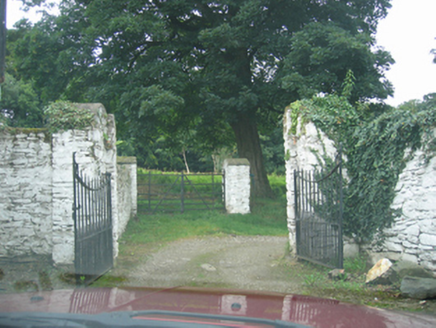
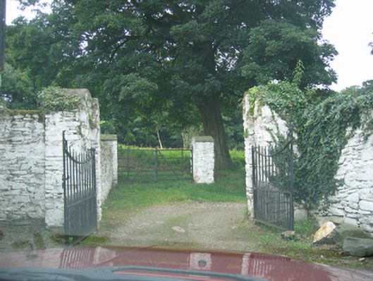
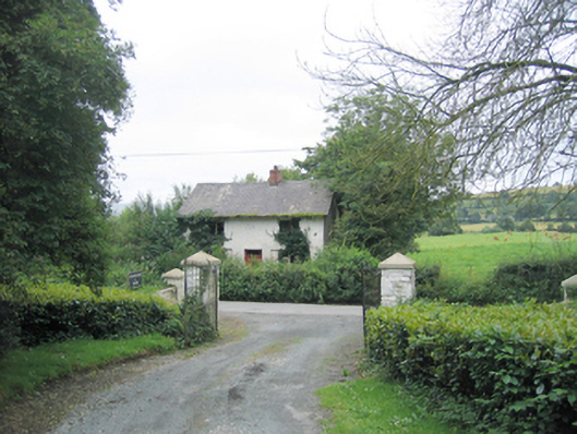
Detached five-bay two-storey L-plan country house, built c.1770 and possibly containing earlier fabric of c.1610, having single-bay single-storey centre porch to centre of front elevation (southeast), added c.1850 and reusing doorcase of c.1820, and having two-storey return and extensions to rear. Modern single-bay single-storey flat-roofed entrance porch to southwest side elevation. Pitched artificial slate roof with eaves course, and with pair of smooth rendered chimneystacks to gable ends, having moulded ashlar coping and terracotta pots. Mono-pitched felt roof to porch with timber fascia to eaves. Roughcast rendered walls over smooth rendered plinth course; smooth rendered walls to rear extension and to porch (ruled-and-lined). Square-headed window openings to front elevation having painted stone sills and six-over-six pane timber sliding sash windows (apparently installed in 1823). Square-headed window openings to side elevations of porch having painted stone sills and six-over-six pane timber sliding sash windows. Square-headed door opening to porch with timber panelled door, doorcase comprising Tuscan pilasters supporting entablature with dentillated cornice and with floral motifs to frieze, and with square-headed overlight with spider’s web fanlight. Doorway approached by flight of cut stone steps. Former segmental-headed carriage-arch to southwest side of return, now infilled with modern glazed door and windows. Set back from road in extensive mature landscaped grounds. Section of hooped wrought-iron railings to south side of house. Complex of outbuildings arranged around yard to north of house. Detached single-bay two-storey outbuilding to west, having pitched natural slate roof with projecting eaves course, cast-iron rainwater goods and chimneystack to west gable. Roughcast rendered walls with square-headed window openings having painted stone sills and six-over-six pane timber sliding sash windows, and square-headed doorway with battened timber door. Detached multiple-bay two-storey outbuilding to northwest, now converted for use as art gallery, having three-bay two-storey section to north and two-storey section to south with loop-hole openings at first floor level, and with single-bay single-storey addition to north having mono-pitched roof. Pitched natural slate roof to larger building, with projecting eaves course, central brick chimneystack, and limewashed rubble stone walls. Square-headed window openings with stone sills and eight-over-eight pane timber sliding sash windows to ground floor level (block to north) and four-over-eight pane at first floor level; square-headed window opening at ground floor level to block to south having fixed-pane multiple-pane timber window with loop-hole openings with brick reveals over at first floor level. Square-headed doorways to block to north and to lean-to extension, having battened timber doors. Multiple-bay two-storey outbuildings to north having pitched and hipped slate roofs, some surviving sections of cast-iron rainwater goods, limewashed rubble stone walls, square-headed timber multiple-pane and replacement windows, square-headed doorways with battened timber doors, and square-headed carriage-arch with battened timber double-leaf door. Detached single-storey outbuilding to west of house having pitched slate roof, rubble stone walls and square-headed openings with cast-iron lattice window and battened timber doors. Courtyard to site having rubble stone boundary walls. Gateway to courtyard having rubble stone gate square-plan piers and wrought-iron double-leaf gates. Remains of walled garden to southwest of house, having three surviving sides with rubble stone walls. Main gateway to east of house comprising pair of square-plan rubble stone piers with wrought-iron double-leaf gate. Gateway flanked by sections of rubble stone walling with terminating square-plan rubble stone piers. Redundant gateway to west of house comprising pier of cast-iron gate posts, square-plan rubble stone piers and hooped wrought-iron double-leaf gate. Derelict three-bay two-storey gate lodge with single-storey extension to rear located south of main gateway, having pitched artificial slate roof with overhanging eaves and central red brick chimneystack with stepped coping, roughcast rendered walls, square-headed replacement timber casement windows with stone sills, and central square-headed timber panelled door with overlight.
Appraisal
This fine and well-proportioned country house, of late eighteenth-century appearance, retains its original form and character. Its visual appeal is enhanced by the retention of salient fabric, including timber sash windows (apparently dating from 1823), while the fine doorcase to the later porch of about 1850, reusing a doorcase of about 1820 with Tuscan pilasters, well-detailed entablature and a delicate fanlight provides an attractive central focus to the main elevation. Much of the interior detailing also survives, including timber panelling to some of the front rooms. The extensive complex of outbuildings to the site, some of which have been converted for use as an art gallery, the remains of the walled garden to the southwest, the gateways to the east and west, and the now derelict gate lodge all add to the setting and context of this dwelling, and provide an interesting historical insight into the extensive resources required to run and maintain a modest country estate during the eighteenth and nineteenth centuries. This house is depicted on the Taylor and Skinner maps of 1777-83 when it was the home of a Mr Kays [Keyes]. Although the house is of late eighteenth-century appearance, it may contain the fabric of an earlier house or houses that date to the early seventeenth-century Plantation of Ulster. The original house was built by the family of Colonel Robert Tasker, who was granted land around Ballindrait about 1610, and who was probably responsible for the establishment of the village. According to local tradition, the army of James II camped at Cavanacor on their way to the Siege of Derry in 1689, and on the 20th of April of that year James II is said to have dined here during the siege. Seemingly, Cavanacor was later afforded James's protection and was one of the few houses in this part of Donegal that was spared being burnt to the ground during the retreat of his armies following the Siege. Apparently while James II was at Cavanacor with the then owner or resident, a John Keyes, his brothers Thomas and Frederick Keyes were inside the walls of Derry defending it against James's armies. Ownership of the house later passed (through marriage) to the Humfrey family from 1823 (Benjamin Humfrey married Mary Keyes in 1823) and remained in their ownership into the twentieth century. The gate lodge, now derelict, was apparently built by Benjamin shortly after his wedding, although the building is not indicated on the Ordnance Survey map of about 1837. This fine house and its ancillary structures are one of the most important elements of the built heritage and history of the Ballindrait area, and form an attractive group in the rural landscape of southeast Donegal.