
Survey Data
Reg No
31206002
Rating
Regional
Categories of Special Interest
Architectural, Scientific, Technical
Original Use
Bridge
In Use As
Bridge
Date
1840 - 1895
Coordinates
126848, 304134
Date Recorded
26/11/2010
Date Updated
--/--/--
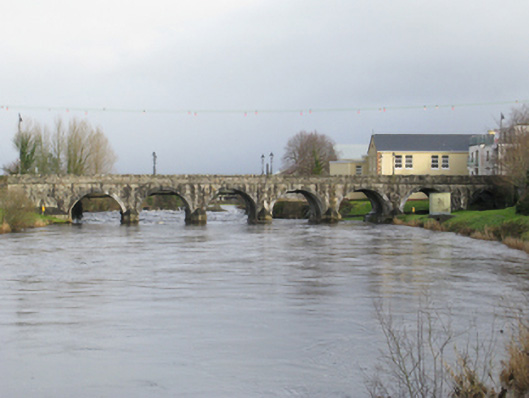
Description
Seven-arch road bridge over river, extant 1895. Tuck pointed coursed rock faced cut-limestone wall to upriver (south-west) elevation centred on drag edged rock faced limestone ashlar triangular cutwaters to piers having drag edged tooled cut-limestone pyramidal capping with drag edged rock faced cut-limestone stringcourses supporting parapets having lichen-covered drag edged rock faced rough hewn limestone coping. Series of seven round arches with drag edged tooled limestone ashlar voussoirs. Sited spanning River Moy with grass banks to river.
Appraisal
A bridge representing an integral component of the civil engineering heritage of County Mayo with the architectural value of the composition, one retaining the basis of 'a very ancient bridge…now in a state of decay' (Lewis 1837 I, 634), confirmed not only by the rock faced surface finish offset by "sparrow pecked" sheer limestone dressings demonstrating good quality workmanship, but also by the elegant "sweep" of the arches making a pleasing visual statement at a crossing over the River Moy: meanwhile, a discreet benchmark remains of additional interest for the connections with cartography and the preparation of maps by the Ordnance Survey (established 1824).