
Survey Data
Reg No
15310030
Original Use
House
In Use As
House
Date
1880 - 1900
Coordinates
242926, 252713
Date Recorded
20/07/2004
Date Updated
--/--/--
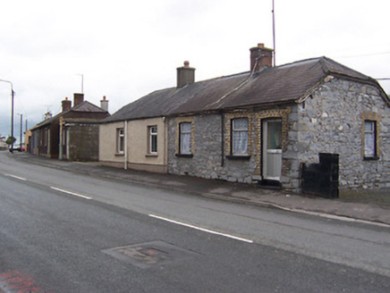
Description
Group of fourteen semi-detracted local authority houses, built c.1890. Now mainly heavily altered and in use as private houses. Half-hipped natural slate roofs with a single central brick/rendered chimneystack to each house. Roughcast rendered walls over smooth rendered plinth. A number of houses have been stripped of render exposing rubble stone construction with brick dressings to the openings. Square-headed window and door openings, now mostly with replacement modern fittings. Road-fronted towards the west end of Mullingar.
Appraisal
A large group of early local authority houses, which retain most of their early form and character despite the loss of the majority of early fittings to the openings. These houses date to a period when a great many buildings of this type were been constructed in Ireland following the passing of the various Land Acts by the British parliament in the late nineteenth and early -twentieth centuries. The vast majority of these buildings of now heavily altered, as is the case with these examples in Mullingar. The large gardens to the rear reflect the social thinking of the time. These modest structures are an interesting part of the social history of Mullingar and reflect the growth of Mullingar to the west at the time