
Survey Data
Reg No
31209057
Rating
Regional
Categories of Special Interest
Architectural, Scientific, Technical
Original Use
Bridge
In Use As
Bridge
Date
1800 - 1838
Coordinates
114434, 290466
Date Recorded
19/11/2008
Date Updated
--/--/--
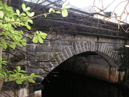
Description
Single-arch road bridge over river, extant 1838[?]. Part creeper- or ivy-covered tuck pointed rock faced limestone ashlar walls between tuck pointed drag edged rock faced limestone ashlar battered piers with dragged cut-limestone chamfered stringcourses supporting benchmark-inscribed parapets having drag edged rock faced cut-limestone coping. Single segmental arch with drag edged rock faced limestone ashlar "crow stepped" voussoirs centred on drag edged rock faced cut-limestone keystones. Sited spanning canalised Castlebar River.
Appraisal
A bridge representing an integral component of the civil engineering heritage of Castlebar with the architectural value of the composition, one recalling a bridge (1852-4) spanning the ill-fated Cong Canal (see 31216002), confirmed not only by the robust rock faced surface finish, but also by the elegant "sweep" of the arch making a pleasing visual statement at a crossing over the canalised Castlebar River: meanwhile, a benchmark remains of additional interest for the connections with cartography and the preparation of maps by the Ordnance Survey (established 1824).