


Survey Data
Reg No
13402348
Rating
National
Categories of Special Interest
Archaeological, Architectural, Artistic, Historical
Previous Name
Tennalick
Original Use
House
Historical Use
Stables
Date
1700 - 1720
Coordinates
221710, 258914
Date Recorded
24/08/2005
Date Updated
--/--/--
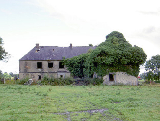
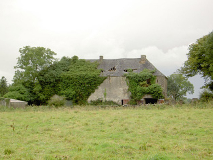
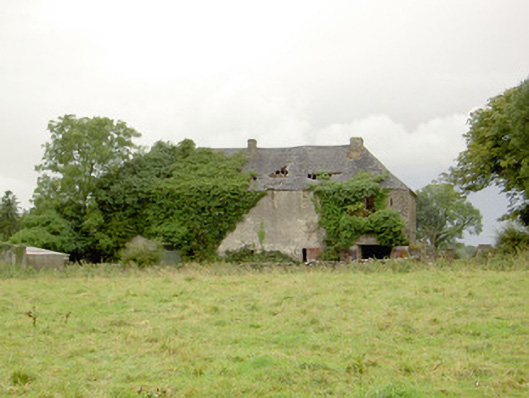
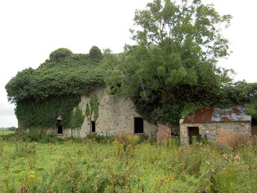
Description
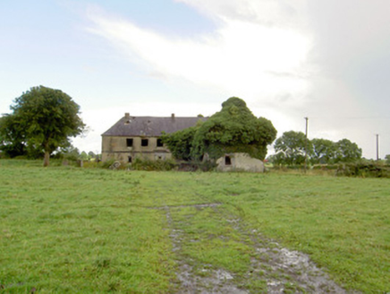
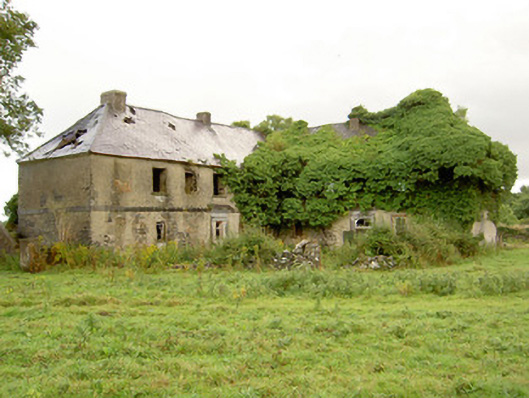
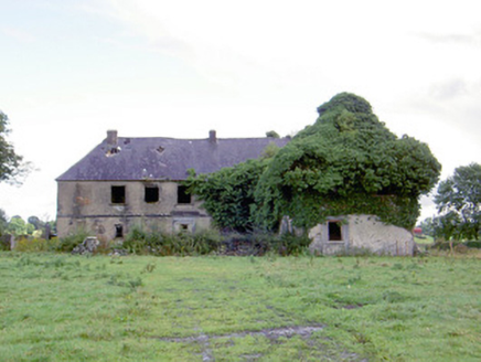
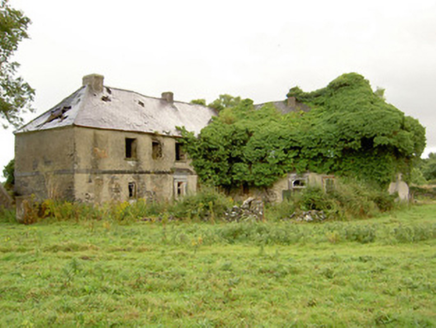
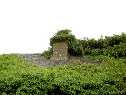
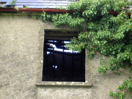
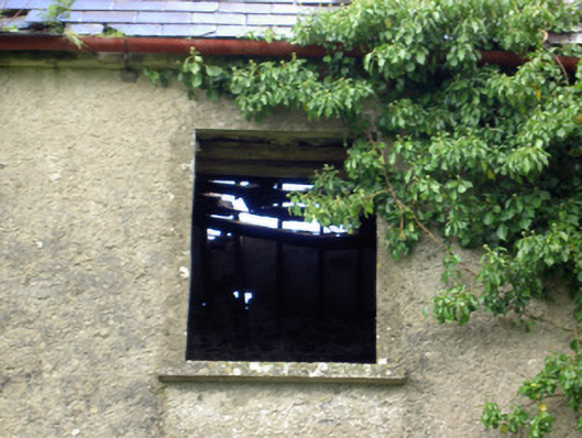
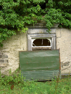
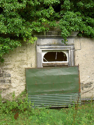
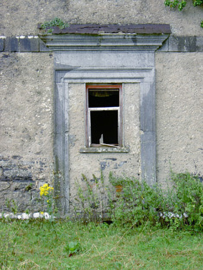
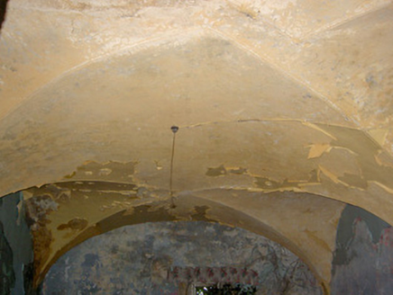
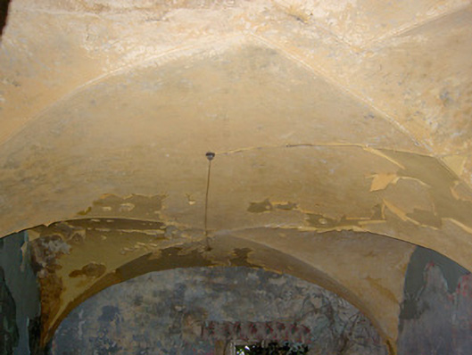
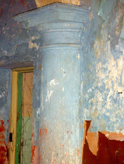
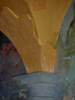
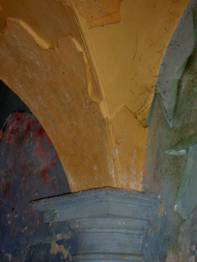
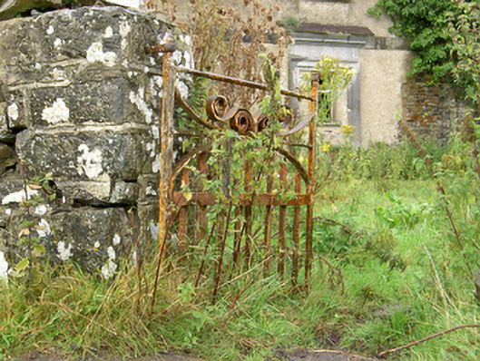
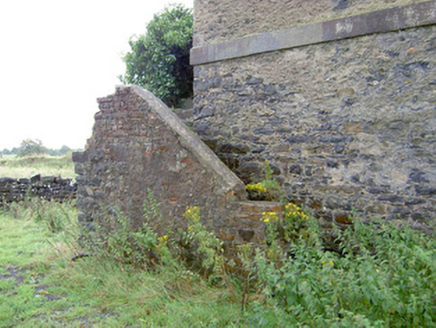
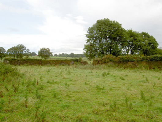
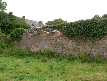
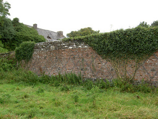
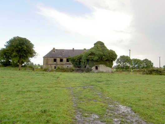
Detached multiple-bay two-storey house, built c. 1710 and probably incorporating the fabric of an earlier house to site c. 1660. Built on L-shaped plan comprising a five-bay two-storey range to the north with a four-bay two-storey range attached to the south end (running east-west). Later partially in use as stables, and later as a dwelling again until c. 1960. Now out of use, derelict and largely overgrown with vegetation. External flight limestone steps (on dog leg-plan) to north gable end of block to the north, having red brick wall to exterior face, giving access to doorway at first floor level to northeast corner (rear). Steeply pitched natural slate roofs with rendered chimneystacks, cast-iron rainwater goods and cut limestone eaves course. Roughcast rendered walls with cut limestone string course between floors and chamfered cut stone plinth course to base. Render now failing exposing rubble stone and squared rubble stone construction. Square-headed window openings with tooled limestone sills; window fittings now largely removed although a number of multiple-pan timber sliding sash window with exposed sash boxes set flush to front elevation remain in-situ. Number of window openings now blocked with brick infill. Square-headed door openings to front elevation (west) of north wing and to north elevation and west gable end of range to south wing. Carved limestone surrounds to door openings with architraves, and having flat friezes with moulded limestone cornices over. Remains of timber spoked fanlight to the doorway to the north elevation of wing to south. Some doorways now blocked with brick and rubble stone infill. Interesting interior with groin vaulted roof to ground floor supported on carved limestone Doric columns/pilasters. Set back from road in extensive mature grounds to the northeast of Ballymahon and the west of Abbeyshrule. Later complex of outbuildings (13402355) arranged around a courtyard to the northeast. Single-storey rubble stone outbuilding to the rear at the northeast end of range to north. Possible remains of late seventeenth-century or early eighteenth-century formal garden to the west and northwest of house (LF023-122----). Remains of walled garden on rectangular-plan to the southeast of house having rubble stone exterior walls faced internally with red brick having inlayed black brick diamond/diaper-work patterns. Similar diaper-work pattern to east face of support wall of flight of exterior stone steps to house. Rubble stone boundary walls to site. Dressed and roughly dressed limestone gate piers (on square-plan) to site, some having wrought-iron gates and pedestrian gates. Elaborate moulded limestone capstones to a number of gate piers (southeast of house), probably reused from an earlier building. Remains of long straight approach avenue (‘the Long Avenue’), c. 2 miles in length, runs to house from the north. Approach avenue now bisected by the Royal Canal a short distance to the north of the house.
Appraisal
Although now sadly derelict, this interesting building represents one of the more important and unusual elements of the architectural heritage of County Longford. It was described by Craig (c. 1976) as ‘a very remarkable building indeed, unlike anything else in Ireland… it looks more like something in the Cotswolds than an Irish building’. The former grandeur of this building can be seen in the elaborate cut stone doorcases with cornices, which are of high artistic merit, and by the cut stone plinth courses and string course. The form of these doorcases suggests that they date to the early-eighteenth century. The unusually steeply pitched roof is an interesting feature that gives this building a distinctive profile and a strong presence in the landscape. It is possible that this building was originally constructed with pitched roofs to both ranges, with the an extra bay(s) added on at some stage and the roof profile changed to the present hipped end profile (the rear elevation (east) of the end bay of the north range is built entirely of brick, which is unlike the rest of the building; the proportions and spacing of the openings to the west elevation of the south range suggests that the end bay here is a later addition) It is also possible that the original building was much more extensive than is currently extant with part of the building later demolished during the late-eighteen/early-nineteenth century. The building retains some of its original fabric including a number of timber sash windows with exposed sash boxes (of probable early eighteenth-century date), although a number of window fittings have been removed/vandalised in recent years which detracts from the architectural expression and character of this building. The ground floor to the interior of this building is notable for the groin vaulted ceilings, which are supported on tooled limestone Doric columns/pilasters. Some sections of plasterwork survive to the interior at ground floor level, which are of mid-to-late eighteenth-century appearance. The diaper-work brick detailing to the inner faces of the walled garden to the southeast, and to the support wall of the exterior flight of cut stone steps, is an interesting and unusual survival, and suggests that the walled garden is an early feature, probably dating to the early eighteenth century. Sensitively restored, this building would be one of the more important elements of the architectural heritage of Country, and indeed of Ireland. The simple rubble stone boundary walls, the gate piers, the remains of the walled garden, the possible remains of an early formal garden (LF023-122----), and the impressive former approach avenue all contribute substantially to the setting of this interesting composition. A former deerpark (townland to the northeast) at the end of the long approach avenue may have been originally associated with this estate. Tennalick House is built on lands occupied by the important O’Farrell family until the early 1650s. The land was seized during the Cromwellian confiscations in 1652, and was granted to Capt. Henry Sankey in 1654 (see below). Some or most of the lands were restored to the O'Farrell's following the Act of Settlement (THE DISPOSSESSED LANDOWNERS OF IRELAND, 1664, - Lists given to the Duke of Ormonde to select his nominees for restoration. The O’Farrells had fought with Ormonde on the Royalist side during the wars) and were still in O’Farrell hands in 1706 (Gillespie and Moran 1991). The O’Farrells owned a castle (LF023-123002-), the remains of which were probably incorporated into a corn mill a short distance to the southwest of Tennalick House. A number of carved and punched stones built into a wall to the southeast of the house may are of sixteenth-century appearance and may be fabric from this earlier castle. The lands (some 1350 acres) of Tennalick were granted to a Capt. Henry Sankey in 1654, and he probably built a house here shortly afterwards. However, it is not clear if the present building dates to this period, of if it was built shortly afterwards (possibly incorporating fabric of an earlier house to site). The building (or earlier building here) was known as Sankey Manor during the first decades of the eighteenth century (1718?) and possibly earlier. It was described by Dowdall in 1682 as ‘on the North Side of the river is Tineleeke, Englished the House of Broad Stone where was formerly an old castle, it is now the estate of Mr. John Sankey, whose father Henry Sankey Esqr. did much to improve and built a large house on it’. John Sankey’s daughter (Bridget?) married George Gore in 1702/3, and it is likely that the house was either rebuilt or extended shortly after this marriage (the notable long straight approach avenue to the north, known as ‘The Long Avenue’, and the possible remains of a formal garden (LF023-122----), are said to date to this period). George Gore (1675 – 1753) was a very important individual, serving as Attorney General of Ireland in 1715 and subsequently as one of the chief Judges of the Common Pleas (from 1724). George Gore was later succeeded by his second son, John Gore (died 1784) who also served as Attorney General of Ireland of Ireland, Lord Chief Justice and Speaker of the Irish House of Commons in 1767 (he was arguably the most important person in Ireland during the late 1760s – 1780s). John Gore was made first Baron Annaly (first creation) in 1766 (his brother Henry Gore (1728 – 1793), M.P. for Longford, was made the First Baron Annaly, second creation, in 1784). The Gore family had a fine townhouse at No. 50, St. Stephen’s Green, Dublin, which was leased from a Gustavus Hume from 1772. This building is now amalgamated with No. 51, St. Stephen’s Green and forms part of the headquarters of the Office of Public Works. It would seem that the Gore family used Tennalick House as an occasional prestige country residence, and spent most of their time residing in Dublin, the heart of political and legal activity. There is a fine marble memorial monument to the Gore family to the interior of Taghshinny Church of Ireland church (13402329) to the northwest. The estate was leased to a Nowlan of Dublin from 1793 and it may have been the home of a Valentine Dillon c. 1800. It later passed into the ownership of Luke White sometime between 1804 – 10 (the White family had a lodge/house at Rathcline during the nineteenth century; and were later Barons Annaly of the third creation from 1863). White subleased the house and land to John McCann and Sons, millers from Drogheda who owned Tennalick Mills (LF023-123002-) to the south (and possibly Cloghan Mills - 13402351). The house and lands may have been sold in 1828 when the 'Mansion and Estate of Tennalick, containing 194 acres' were put up for sale for 'lives renewable forever at a pepper corn fine' (Newspaper Advert 1828). The McCann’s reputedly used part of the house as stabling for dray horses (used for pulling barges along the Royal Canal). The ground floor level of the south wing appears to have been reused as these stables, whilst the first-floor level appears to have been used as a store for animal feed. Slots at regular intervals in the side walls of this floor were used for depositing feed for the animals in the stables below. Lewis (1837) described Tennalick House as ‘once the residence of Lord Annaly.. has long been in ruins’, suggesting that the house was unoccupied for a considerable period at this time (probably since 1793, following the death of Henry Gore). The building was partially in use as a house by the end of the nineteenth century and a Harry McCann lived at Tennalick in 1894 (Slater's Directory). It was later the home the Kilmurray family until c. 1970s, when it became disused again.