
Survey Data
Reg No
20401408
Rating
Regional
Categories of Special Interest
Architectural
Original Use
Folly
In Use As
Folly
Date
1830 - 1840
Coordinates
103900, 192289
Date Recorded
09/09/1997
Date Updated
--/--/--
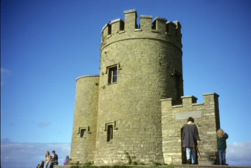
Description
Freestanding single-bay two-stage tower, built 1835, on a circular plan with single-bay two-stage lower turret (west) on a circular plan. In ruins, 1942. Roofs not visible behind parapets. Repointed coursed cut-limestone walls on battered base with cut-limestone stringcourse supporting battlemented parapet having cut-limestone coping; repointed coursed cut-limestone walls (turret) with concrete coping to parapet. Square-headed window openings with shallow sills, and cut-limestone lintels with hood mouldings framing timber casement windows. Square-headed window openings (turret) with shallow sills, and cut-limestone lintels with hood mouldings framing timber casement windows. Set on cut-limestone stepped podium on clifftop. NOTE: Erected by Cornelius O'Brien MP (1782-1857) 'for the accommodation of visitors [who obtain] a magnificent view embracing the whole line of coast from Loop Head to the northern extremity of the bay of Galway together with the Arran Isles and a vast expanse of the Atlantic Ocean' (Lewis 1837 II, 166). Originally larger with a second single-stage tower showing a diadem-like battlemented parapet as captured in a photograph by Robert French (1841-1917) of Dublin [NLI L_CAB_06217]; the second tower had collapsed by the time O'Brien's Tower was photographed (1942) by the Irish Tourist Association [NLI ITA 269/1].